Cím: 13500 (From 13500 To 13599) COUNTY ROAD 17, BLAIR, NE 68008-5591, USA
Mi az 68008-5591? 68008-5591 az 13500 (From 13500 To 13599) COUNTY ROAD 17, BLAIR, NE, USA 5 jegyü irányitószám plusz 4 számjegy.Alábbiakban részletes információért.
68008-5591 Alapinformációk

-
Irányítószám 5 Plus 4:
68008-5591 -
Irányítószám 5:
68008 -
Plus 4?55914-digits that are used to identify a geographic segment within the 5-digit delivery area, such as a city block or a group of apartments or an individual high-volume receiver of mail, or any other unit that could use an extra identifier to aid in efficient mail sorting and delivery. This code is the low end of the range of +4 Codes that pertain to this ZIP Code. ZIP+4 Codes associated with nondelivery areas are composed of valid ZIP sector numbers and "ND" for the ZIP segment number, for example 12345-12ND. Non-deliverable areas are areas to which the USPS does not deliver mail, such as vacant lots and land that borders railroad tracks. Mailers should not match an address identified as a nondelivery area. If you absolutely must have numeric characters in the Plus4Code column, you may treat "ND" values as "00" (zero zero).:
-
Ország:
U.S. - Egyesült Államok -
Állam:
NE - Nebraska -
Megye:
CountyFIPS: 31177 - Washington County -
Város:
BLAIR -
Utca?COUNTY ROAD 17The official name of a street as assigned by a local governing authority. The Street Name column contains only the street name and does not include directionals (EAST, WEST, etc.) or suffixes (ST, DR, BLVD, etc.). This element may also contain literals, such as PO BOX, GENERAL DELIVERY, USS, PSC, or UNIT. Numeric street names that have numeric components that are four characters (or less) in length at are justified such that the low-order digit of the number is positioned in the fourth position of the street name column. This shift is made so that the numeric street names appear in numeric sequence.:
-
Rekord Típus?S: UtcaAn alphabetic value that identifies the type of data in the record. Record type codes include the following: G = General delivery H = Highrise F = Firm S = Street P = PO box R = Rural route/highway contract:
Cím

- Elsődleges Cím Alacsony Szám?
A house, rural route, highway contract box, or post office box number; the numeric or alphanumeric component of an address preceding the street name; the low-end address in a range of addresses. Often referred to as house number.: 13500
- Elsődleges Cím Magas Szám?
A house, rural route, contract box, or Post Office box number. The numeric or alphanumeric component of an address preceding the street name. The high-end address in a range of addresses. Often referred to as house number.: 13599
- Elsődleges Cím Páros / Páratlan Kód?
Code that identifies the side or sides of a street for which a given address range is applicable. For street, highrise, firm and multi-carrier records, B = Both sides of a street, E = Even side of a street (even-numbered addresses in the range); O = Odd side of a street (odd-numbered addresses in the range). For general delivery, post office box, and rural route/highway contract records, this code will always be "B" (both).: Both of Odd and Even
- Elsődleges Sorozat: 13500, 13501, 13502, 13503, 13504, 13505, 13506, 13507, 13508, 13509, 13510, 13511, 13512, 13513, 13514, 13515, 13516, 13517, 13518, 13519, 13520, 13521, 13522, 13523, 13524, 13525, 13526, 13527, 13528, 13529, 13530, 13531, 13532, 13533, 13534, 13535, 13536, 13537, 13538, 13539, 13540, 13541, 13542, 13543, 13544, 13545, 13546, 13547, 13548, 13549, 13550, 13551, 13552, 13553, 13554, 13555, 13556, 13557, 13558, 13559, 13560, 13561, 13562, 13563, 13564, 13565, 13566, 13567, 13568, 13569, 13570, 13571, 13572, 13573, 13574, 13575, 13576, 13577, 13578, 13579, 13580, 13581, 13582, 13583, 13584, 13585, 13586, 13587, 13588, 13589, 13590, 13591, 13592, 13593, 13594, 13595, 13596, 13597, 13598, 13599.
A teljes lista megtekintéséhez kattintson a "További címpéldák"-re.
13500 COUNTY ROAD 17, BLAIR, NE 68008-5591
13501 COUNTY ROAD 17, BLAIR, NE 68008-5591
13502 COUNTY ROAD 17, BLAIR, NE 68008-5591
13503 COUNTY ROAD 17, BLAIR, NE 68008-5591
13504 COUNTY ROAD 17, BLAIR, NE 68008-5591
13505 COUNTY ROAD 17, BLAIR, NE 68008-5591
13506 COUNTY ROAD 17, BLAIR, NE 68008-5591
13507 COUNTY ROAD 17, BLAIR, NE 68008-5591
13508 COUNTY ROAD 17, BLAIR, NE 68008-5591
13509 COUNTY ROAD 17, BLAIR, NE 68008-5591
13510 COUNTY ROAD 17, BLAIR, NE 68008-5591
13511 COUNTY ROAD 17, BLAIR, NE 68008-5591
13512 COUNTY ROAD 17, BLAIR, NE 68008-5591
13513 COUNTY ROAD 17, BLAIR, NE 68008-5591
13514 COUNTY ROAD 17, BLAIR, NE 68008-5591
13515 COUNTY ROAD 17, BLAIR, NE 68008-5591
13516 COUNTY ROAD 17, BLAIR, NE 68008-5591
13517 COUNTY ROAD 17, BLAIR, NE 68008-5591
13518 COUNTY ROAD 17, BLAIR, NE 68008-5591
13519 COUNTY ROAD 17, BLAIR, NE 68008-5591
13520 COUNTY ROAD 17, BLAIR, NE 68008-5591
13521 COUNTY ROAD 17, BLAIR, NE 68008-5591
13522 COUNTY ROAD 17, BLAIR, NE 68008-5591
13523 COUNTY ROAD 17, BLAIR, NE 68008-5591
13524 COUNTY ROAD 17, BLAIR, NE 68008-5591
13525 COUNTY ROAD 17, BLAIR, NE 68008-5591
13526 COUNTY ROAD 17, BLAIR, NE 68008-5591
13527 COUNTY ROAD 17, BLAIR, NE 68008-5591
13528 COUNTY ROAD 17, BLAIR, NE 68008-5591
13529 COUNTY ROAD 17, BLAIR, NE 68008-5591
13530 COUNTY ROAD 17, BLAIR, NE 68008-5591
13531 COUNTY ROAD 17, BLAIR, NE 68008-5591
13532 COUNTY ROAD 17, BLAIR, NE 68008-5591
13533 COUNTY ROAD 17, BLAIR, NE 68008-5591
13534 COUNTY ROAD 17, BLAIR, NE 68008-5591
13535 COUNTY ROAD 17, BLAIR, NE 68008-5591
13536 COUNTY ROAD 17, BLAIR, NE 68008-5591
13537 COUNTY ROAD 17, BLAIR, NE 68008-5591
13538 COUNTY ROAD 17, BLAIR, NE 68008-5591
13539 COUNTY ROAD 17, BLAIR, NE 68008-5591
13540 COUNTY ROAD 17, BLAIR, NE 68008-5591
13541 COUNTY ROAD 17, BLAIR, NE 68008-5591
13542 COUNTY ROAD 17, BLAIR, NE 68008-5591
13543 COUNTY ROAD 17, BLAIR, NE 68008-5591
13544 COUNTY ROAD 17, BLAIR, NE 68008-5591
13545 COUNTY ROAD 17, BLAIR, NE 68008-5591
13546 COUNTY ROAD 17, BLAIR, NE 68008-5591
13547 COUNTY ROAD 17, BLAIR, NE 68008-5591
13548 COUNTY ROAD 17, BLAIR, NE 68008-5591
13549 COUNTY ROAD 17, BLAIR, NE 68008-5591
13550 COUNTY ROAD 17, BLAIR, NE 68008-5591
13551 COUNTY ROAD 17, BLAIR, NE 68008-5591
13552 COUNTY ROAD 17, BLAIR, NE 68008-5591
13553 COUNTY ROAD 17, BLAIR, NE 68008-5591
13554 COUNTY ROAD 17, BLAIR, NE 68008-5591
13555 COUNTY ROAD 17, BLAIR, NE 68008-5591
13556 COUNTY ROAD 17, BLAIR, NE 68008-5591
13557 COUNTY ROAD 17, BLAIR, NE 68008-5591
13558 COUNTY ROAD 17, BLAIR, NE 68008-5591
13559 COUNTY ROAD 17, BLAIR, NE 68008-5591
13560 COUNTY ROAD 17, BLAIR, NE 68008-5591
13561 COUNTY ROAD 17, BLAIR, NE 68008-5591
13562 COUNTY ROAD 17, BLAIR, NE 68008-5591
13563 COUNTY ROAD 17, BLAIR, NE 68008-5591
13564 COUNTY ROAD 17, BLAIR, NE 68008-5591
13565 COUNTY ROAD 17, BLAIR, NE 68008-5591
13566 COUNTY ROAD 17, BLAIR, NE 68008-5591
13567 COUNTY ROAD 17, BLAIR, NE 68008-5591
13568 COUNTY ROAD 17, BLAIR, NE 68008-5591
13569 COUNTY ROAD 17, BLAIR, NE 68008-5591
13570 COUNTY ROAD 17, BLAIR, NE 68008-5591
13571 COUNTY ROAD 17, BLAIR, NE 68008-5591
13572 COUNTY ROAD 17, BLAIR, NE 68008-5591
13573 COUNTY ROAD 17, BLAIR, NE 68008-5591
13574 COUNTY ROAD 17, BLAIR, NE 68008-5591
13575 COUNTY ROAD 17, BLAIR, NE 68008-5591
13576 COUNTY ROAD 17, BLAIR, NE 68008-5591
13577 COUNTY ROAD 17, BLAIR, NE 68008-5591
13578 COUNTY ROAD 17, BLAIR, NE 68008-5591
13579 COUNTY ROAD 17, BLAIR, NE 68008-5591
13580 COUNTY ROAD 17, BLAIR, NE 68008-5591
13581 COUNTY ROAD 17, BLAIR, NE 68008-5591
13582 COUNTY ROAD 17, BLAIR, NE 68008-5591
13583 COUNTY ROAD 17, BLAIR, NE 68008-5591
13584 COUNTY ROAD 17, BLAIR, NE 68008-5591
13585 COUNTY ROAD 17, BLAIR, NE 68008-5591
13586 COUNTY ROAD 17, BLAIR, NE 68008-5591
13587 COUNTY ROAD 17, BLAIR, NE 68008-5591
13588 COUNTY ROAD 17, BLAIR, NE 68008-5591
13589 COUNTY ROAD 17, BLAIR, NE 68008-5591
13590 COUNTY ROAD 17, BLAIR, NE 68008-5591
13591 COUNTY ROAD 17, BLAIR, NE 68008-5591
13592 COUNTY ROAD 17, BLAIR, NE 68008-5591
13593 COUNTY ROAD 17, BLAIR, NE 68008-5591
13594 COUNTY ROAD 17, BLAIR, NE 68008-5591
13595 COUNTY ROAD 17, BLAIR, NE 68008-5591
13596 COUNTY ROAD 17, BLAIR, NE 68008-5591
13597 COUNTY ROAD 17, BLAIR, NE 68008-5591
13598 COUNTY ROAD 17, BLAIR, NE 68008-5591
13599 COUNTY ROAD 17, BLAIR, NE 68008-5591
Cím Példa
BLAIR NE 68008-5591
UNITED STATES OF AMERICA
68008-5591 Boríték Példa

-
Ez egy példa az amerikai borítékra. Töltse ki a feladó adatait a bal felső sarokban, a címzett adatait pedig a jobb alsó sarokban. A szükséges információ a feladó/címzett teljes neve, utcája, városa, állam és irányítószám. A címzett információit megadtuk hivatkozásul. Általában, ha nem biztos a teljes 9 jegyű irányítószámban, akkor csak az 5 jegyű irányítószámot töltse ki a csomag elvesztésének elkerülése érdekében.

68008-5591 Alapvető jelentés
-
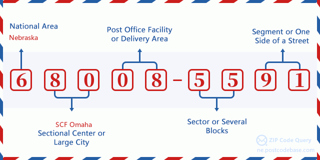
Mit jelent az 68008-5591 irányítószám minden számjegye? Az irányítószám két részből áll, az első öt számjegy a postahivatalig, az utolsó négy számjegy pedig egy földrajzi szegmenst azonosíthat az ötjegyű kézbesítési területen belül. A 6-7 számjegy egy szektort vagy több blokkot, a 8-9 számjegy pedig egy utcaszakaszt vagy egy oldalt jelöl.

- ·Hordozó Útvonal ID?
A 4-digit code assigned to a mail delivery or collection route within a 5-digit ZIP Code. The first character of this identification is alphabetical, and the last three are numeric: Bnnn = PO box Hnnn = Highway contract Rnnn = Rural route Cnnn = City delivery Gnnn = General delivery: R001 (Vidéki Út)
- ·Irányítószámhoz Hozzáad Alacsony Szektort?
The ZIP Add-On Low Sector and the ZIP Add-On Low Segment together form the ZIP Add-On Low Number. The ZIP Add-On Low Number is the last four positions of a ZIP+4 code; the low-end ZIP add-on in a range of codes; the add-on of the first ZIP+4 code in a consecutive series of ZIP+4 codes assigned to the delivery address. For example, most delivery addresses are assigned a single ZIP+4 code. However, large companies may be given a range of ZIP+4 codes that can be used to route mail to specific departments. A range of ZIP+4 codes can also be assigned to a corresponding range of post office boxes, and each box is mapped, one-to-one, with a ZIP+4 code in the range. A single post office box can also be assigned a range of ZIP+4 codes.: 55
- ·Irányítószámhoz Hozzáad Alacsony Szegmenst?
The ZIP Add-On Low Sector and the ZIP Add-On Low Segment together form the ZIP Add-On Low Number. The ZIP Add-On Low Number is the last four positions of a ZIP+4 code; the low-end ZIP add-on in a range of codes; the add-on of the first ZIP+4 code in a consecutive series of ZIP+4 codes assigned to the delivery address. For example, most delivery addresses are assigned a single ZIP+4 code. However, large companies may be given a range of ZIP+4 codes that can be used to route mail to specific departments. A range of ZIP+4 codes can also be assigned to a corresponding range of post office boxes, and each box is mapped, one-to-one, with a ZIP+4 code in the range. A single post office box can also be assigned a range of ZIP+4 codes.: 91
- ·Irányítószámhoz Hozzáad Magas Szektort?
The ZIP Add-On High Sector and the ZIP Add-On High Segment together form the ZIP Add-On High Number, which is the high-end ZIP add-on in a range of codes; the add-on of the last ZIP+4 code in a consecutive series of ZIP+4 codes assigned to the delivery address. Most delivery addresses are assigned a single ZIP+4 code; however, large companies may be given a range of ZIP+4 codes that can be used to route mail to specific departments. A range of ZIP+4 codes can also be assigned to a corresponding range of post office boxes, and each box is mapped, one-to-one, with a ZIP+4 code in the range. A single post office box can also be assigned a range of ZIP+4 codes. (See also ZIP Add-On Code.): 55
- ·Irányítószámhoz Hozzáad Magas Szegmenst?
The ZIP Add-On High Sector and the ZIP Add-On High Segment together form the ZIP Add-On High Number, which is the high-end ZIP add-on in a range of codes; the add-on of the last ZIP+4 code in a consecutive series of ZIP+4 codes assigned to the delivery address. Most delivery addresses are assigned a single ZIP+4 code; however, large companies may be given a range of ZIP+4 codes that can be used to route mail to specific departments. A range of ZIP+4 codes can also be assigned to a corresponding range of post office boxes, and each box is mapped, one-to-one, with a ZIP+4 code in the range. A single post office box can also be assigned a range of ZIP+4 codes. (See also ZIP Add-On Code.): 91
- ·Irányítószám Melléklet: 5591
- ·Sorozat?
The range of +4 codes. Summing the +4 Code and the +4 Range will give you the high end of the range of +4 Codes that pertain to this ZIP Code.: 0
- ·Bázis Alternatív Kód?
Code that specifies whether a record is a base (preferred) or alternate record. Base records (represented as "B") can represent a range of addresses or an individual address, such as a firm record, while alternate records (represented as "A") are individual delivery points. Government deliveries will only be listed on alternate records with the appropriate government building indicator (federal, state, or city) set.: Alap
- ·Pénzügy Száma?
A code assigned to Postal Service facilities (primarily post offices) to collect cost and statistical data and compile revenue and expense data. The state number comprises the first two positions of the finance number.: 301020
- ·Kerület Kongresszusi Szám?
A standard value identifying a geographic area within the United States served by a member of the US House of Representatives or Senate. If Army/Air Force (APO) or fleet post office (FPO), this column will be blank. If there is only one member of Congress within a state, the code will be "AL" (at large).: 01
- ·Előnyben Last Line Város Állam Kulcs?
An index to the City State file that provides the preferred last-line name for this address range.: W19528
Online Térkép

Ez az online térkép cim 13500 COUNTY ROAD 17 BLAIR. Lehet használni a Zoom in / out-ot. A térkép információk csak tájékoztató jellegü. A térkép információk csak tájékoztató jellegü.
Cím: 13500 (From 13500 To 13599) COUNTY ROAD 17, BLAIR, NE 68008-5591, USA
Hozzászólás


Új hozzászólás