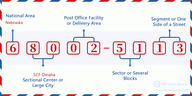
20300 COUNTY ROAD 26, ARLINGTON, NE 68002-5113
20301 COUNTY ROAD 26, ARLINGTON, NE 68002-5113
20302 COUNTY ROAD 26, ARLINGTON, NE 68002-5113
20303 COUNTY ROAD 26, ARLINGTON, NE 68002-5113
20304 COUNTY ROAD 26, ARLINGTON, NE 68002-5113
20305 COUNTY ROAD 26, ARLINGTON, NE 68002-5113
20306 COUNTY ROAD 26, ARLINGTON, NE 68002-5113
20307 COUNTY ROAD 26, ARLINGTON, NE 68002-5113
20308 COUNTY ROAD 26, ARLINGTON, NE 68002-5113
20309 COUNTY ROAD 26, ARLINGTON, NE 68002-5113
20310 COUNTY ROAD 26, ARLINGTON, NE 68002-5113
20311 COUNTY ROAD 26, ARLINGTON, NE 68002-5113
20312 COUNTY ROAD 26, ARLINGTON, NE 68002-5113
20313 COUNTY ROAD 26, ARLINGTON, NE 68002-5113
20314 COUNTY ROAD 26, ARLINGTON, NE 68002-5113
20315 COUNTY ROAD 26, ARLINGTON, NE 68002-5113
20316 COUNTY ROAD 26, ARLINGTON, NE 68002-5113
20317 COUNTY ROAD 26, ARLINGTON, NE 68002-5113
20318 COUNTY ROAD 26, ARLINGTON, NE 68002-5113
20319 COUNTY ROAD 26, ARLINGTON, NE 68002-5113
20320 COUNTY ROAD 26, ARLINGTON, NE 68002-5113
20321 COUNTY ROAD 26, ARLINGTON, NE 68002-5113
20322 COUNTY ROAD 26, ARLINGTON, NE 68002-5113
20323 COUNTY ROAD 26, ARLINGTON, NE 68002-5113
20324 COUNTY ROAD 26, ARLINGTON, NE 68002-5113
20325 COUNTY ROAD 26, ARLINGTON, NE 68002-5113
20326 COUNTY ROAD 26, ARLINGTON, NE 68002-5113
20327 COUNTY ROAD 26, ARLINGTON, NE 68002-5113
20328 COUNTY ROAD 26, ARLINGTON, NE 68002-5113
20329 COUNTY ROAD 26, ARLINGTON, NE 68002-5113
20330 COUNTY ROAD 26, ARLINGTON, NE 68002-5113
20331 COUNTY ROAD 26, ARLINGTON, NE 68002-5113
20332 COUNTY ROAD 26, ARLINGTON, NE 68002-5113
20333 COUNTY ROAD 26, ARLINGTON, NE 68002-5113
20334 COUNTY ROAD 26, ARLINGTON, NE 68002-5113
20335 COUNTY ROAD 26, ARLINGTON, NE 68002-5113
20336 COUNTY ROAD 26, ARLINGTON, NE 68002-5113
20337 COUNTY ROAD 26, ARLINGTON, NE 68002-5113
20338 COUNTY ROAD 26, ARLINGTON, NE 68002-5113
20339 COUNTY ROAD 26, ARLINGTON, NE 68002-5113
20340 COUNTY ROAD 26, ARLINGTON, NE 68002-5113
20341 COUNTY ROAD 26, ARLINGTON, NE 68002-5113
20342 COUNTY ROAD 26, ARLINGTON, NE 68002-5113
20343 COUNTY ROAD 26, ARLINGTON, NE 68002-5113
20344 COUNTY ROAD 26, ARLINGTON, NE 68002-5113
20345 COUNTY ROAD 26, ARLINGTON, NE 68002-5113
20346 COUNTY ROAD 26, ARLINGTON, NE 68002-5113
20347 COUNTY ROAD 26, ARLINGTON, NE 68002-5113
20348 COUNTY ROAD 26, ARLINGTON, NE 68002-5113
20349 COUNTY ROAD 26, ARLINGTON, NE 68002-5113
20350 COUNTY ROAD 26, ARLINGTON, NE 68002-5113
20351 COUNTY ROAD 26, ARLINGTON, NE 68002-5113
20352 COUNTY ROAD 26, ARLINGTON, NE 68002-5113
20353 COUNTY ROAD 26, ARLINGTON, NE 68002-5113
20354 COUNTY ROAD 26, ARLINGTON, NE 68002-5113
20355 COUNTY ROAD 26, ARLINGTON, NE 68002-5113
20356 COUNTY ROAD 26, ARLINGTON, NE 68002-5113
20357 COUNTY ROAD 26, ARLINGTON, NE 68002-5113
20358 COUNTY ROAD 26, ARLINGTON, NE 68002-5113
20359 COUNTY ROAD 26, ARLINGTON, NE 68002-5113
20360 COUNTY ROAD 26, ARLINGTON, NE 68002-5113
20361 COUNTY ROAD 26, ARLINGTON, NE 68002-5113
20362 COUNTY ROAD 26, ARLINGTON, NE 68002-5113
20363 COUNTY ROAD 26, ARLINGTON, NE 68002-5113
20364 COUNTY ROAD 26, ARLINGTON, NE 68002-5113
20365 COUNTY ROAD 26, ARLINGTON, NE 68002-5113
20366 COUNTY ROAD 26, ARLINGTON, NE 68002-5113
20367 COUNTY ROAD 26, ARLINGTON, NE 68002-5113
20368 COUNTY ROAD 26, ARLINGTON, NE 68002-5113
20369 COUNTY ROAD 26, ARLINGTON, NE 68002-5113
20370 COUNTY ROAD 26, ARLINGTON, NE 68002-5113
20371 COUNTY ROAD 26, ARLINGTON, NE 68002-5113
20372 COUNTY ROAD 26, ARLINGTON, NE 68002-5113
20373 COUNTY ROAD 26, ARLINGTON, NE 68002-5113
20374 COUNTY ROAD 26, ARLINGTON, NE 68002-5113
20375 COUNTY ROAD 26, ARLINGTON, NE 68002-5113
20376 COUNTY ROAD 26, ARLINGTON, NE 68002-5113
20377 COUNTY ROAD 26, ARLINGTON, NE 68002-5113
20378 COUNTY ROAD 26, ARLINGTON, NE 68002-5113
20379 COUNTY ROAD 26, ARLINGTON, NE 68002-5113
20380 COUNTY ROAD 26, ARLINGTON, NE 68002-5113
20381 COUNTY ROAD 26, ARLINGTON, NE 68002-5113
20382 COUNTY ROAD 26, ARLINGTON, NE 68002-5113
20383 COUNTY ROAD 26, ARLINGTON, NE 68002-5113
20384 COUNTY ROAD 26, ARLINGTON, NE 68002-5113
20385 COUNTY ROAD 26, ARLINGTON, NE 68002-5113
20386 COUNTY ROAD 26, ARLINGTON, NE 68002-5113
20387 COUNTY ROAD 26, ARLINGTON, NE 68002-5113
20388 COUNTY ROAD 26, ARLINGTON, NE 68002-5113
20389 COUNTY ROAD 26, ARLINGTON, NE 68002-5113
20390 COUNTY ROAD 26, ARLINGTON, NE 68002-5113
20391 COUNTY ROAD 26, ARLINGTON, NE 68002-5113
20392 COUNTY ROAD 26, ARLINGTON, NE 68002-5113
20393 COUNTY ROAD 26, ARLINGTON, NE 68002-5113
20394 COUNTY ROAD 26, ARLINGTON, NE 68002-5113
20395 COUNTY ROAD 26, ARLINGTON, NE 68002-5113
20396 COUNTY ROAD 26, ARLINGTON, NE 68002-5113
20397 COUNTY ROAD 26, ARLINGTON, NE 68002-5113
20398 COUNTY ROAD 26, ARLINGTON, NE 68002-5113
20399 COUNTY ROAD 26, ARLINGTON, NE 68002-5113


Aggiungi un commento