Адрес: 20300 (From 20300 To 20399) COUNTY ROAD 26, ARLINGTON, NE 68002-5113, USA
Что такое 68002-5113? 68002-5113 является почтовым индексом 20300 (From 20300 To 20399) COUNTY ROAD 26, ARLINGTON, NE, USA 5 плюс 4. Ниже приведена подробная информация.
68002-5113 Основная информация

-
Индекс 5 Plus 4:
68002-5113 -
Индекс 5:
68002 -
Plus 4?51134-digits that are used to identify a geographic segment within the 5-digit delivery area, such as a city block or a group of apartments or an individual high-volume receiver of mail, or any other unit that could use an extra identifier to aid in efficient mail sorting and delivery. This code is the low end of the range of +4 Codes that pertain to this ZIP Code. ZIP+4 Codes associated with nondelivery areas are composed of valid ZIP sector numbers and "ND" for the ZIP segment number, for example 12345-12ND. Non-deliverable areas are areas to which the USPS does not deliver mail, such as vacant lots and land that borders railroad tracks. Mailers should not match an address identified as a nondelivery area. If you absolutely must have numeric characters in the Plus4Code column, you may treat "ND" values as "00" (zero zero).:
-
Страна:
U.S. - Соединенные Штаты -
Область :
NE - Небраска -
Округ:
CountyFIPS: 31177 - Washington County -
Город:
ARLINGTON -
Улица?COUNTY ROAD 26The official name of a street as assigned by a local governing authority. The Street Name column contains only the street name and does not include directionals (EAST, WEST, etc.) or suffixes (ST, DR, BLVD, etc.). This element may also contain literals, such as PO BOX, GENERAL DELIVERY, USS, PSC, or UNIT. Numeric street names that have numeric components that are four characters (or less) in length at are justified such that the low-order digit of the number is positioned in the fourth position of the street name column. This shift is made so that the numeric street names appear in numeric sequence.:
-
Тип записи?S: УлицаAn alphabetic value that identifies the type of data in the record. Record type codes include the following: G = General delivery H = Highrise F = Firm S = Street P = PO box R = Rural route/highway contract:
Адрес

- Малое число главного адреса ?
A house, rural route, highway contract box, or post office box number; the numeric or alphanumeric component of an address preceding the street name; the low-end address in a range of addresses. Often referred to as house number.: 20300
- Большое число главного адреса ?
A house, rural route, contract box, or Post Office box number. The numeric or alphanumeric component of an address preceding the street name. The high-end address in a range of addresses. Often referred to as house number.: 20399
- Нечетный / четный код главного адреса ?
Code that identifies the side or sides of a street for which a given address range is applicable. For street, highrise, firm and multi-carrier records, B = Both sides of a street, E = Even side of a street (even-numbered addresses in the range); O = Odd side of a street (odd-numbered addresses in the range). For general delivery, post office box, and rural route/highway contract records, this code will always be "B" (both).: Both of Odd and Even
- Первичный Диапазон: 20300, 20301, 20302, 20303, 20304, 20305, 20306, 20307, 20308, 20309, 20310, 20311, 20312, 20313, 20314, 20315, 20316, 20317, 20318, 20319, 20320, 20321, 20322, 20323, 20324, 20325, 20326, 20327, 20328, 20329, 20330, 20331, 20332, 20333, 20334, 20335, 20336, 20337, 20338, 20339, 20340, 20341, 20342, 20343, 20344, 20345, 20346, 20347, 20348, 20349, 20350, 20351, 20352, 20353, 20354, 20355, 20356, 20357, 20358, 20359, 20360, 20361, 20362, 20363, 20364, 20365, 20366, 20367, 20368, 20369, 20370, 20371, 20372, 20373, 20374, 20375, 20376, 20377, 20378, 20379, 20380, 20381, 20382, 20383, 20384, 20385, 20386, 20387, 20388, 20389, 20390, 20391, 20392, 20393, 20394, 20395, 20396, 20397, 20398, 20399.
Нажмите "Больше примеров адресов", чтобы просмотреть весь список.
20300 COUNTY ROAD 26, ARLINGTON, NE 68002-5113
20301 COUNTY ROAD 26, ARLINGTON, NE 68002-5113
20302 COUNTY ROAD 26, ARLINGTON, NE 68002-5113
20303 COUNTY ROAD 26, ARLINGTON, NE 68002-5113
20304 COUNTY ROAD 26, ARLINGTON, NE 68002-5113
20305 COUNTY ROAD 26, ARLINGTON, NE 68002-5113
20306 COUNTY ROAD 26, ARLINGTON, NE 68002-5113
20307 COUNTY ROAD 26, ARLINGTON, NE 68002-5113
20308 COUNTY ROAD 26, ARLINGTON, NE 68002-5113
20309 COUNTY ROAD 26, ARLINGTON, NE 68002-5113
20310 COUNTY ROAD 26, ARLINGTON, NE 68002-5113
20311 COUNTY ROAD 26, ARLINGTON, NE 68002-5113
20312 COUNTY ROAD 26, ARLINGTON, NE 68002-5113
20313 COUNTY ROAD 26, ARLINGTON, NE 68002-5113
20314 COUNTY ROAD 26, ARLINGTON, NE 68002-5113
20315 COUNTY ROAD 26, ARLINGTON, NE 68002-5113
20316 COUNTY ROAD 26, ARLINGTON, NE 68002-5113
20317 COUNTY ROAD 26, ARLINGTON, NE 68002-5113
20318 COUNTY ROAD 26, ARLINGTON, NE 68002-5113
20319 COUNTY ROAD 26, ARLINGTON, NE 68002-5113
20320 COUNTY ROAD 26, ARLINGTON, NE 68002-5113
20321 COUNTY ROAD 26, ARLINGTON, NE 68002-5113
20322 COUNTY ROAD 26, ARLINGTON, NE 68002-5113
20323 COUNTY ROAD 26, ARLINGTON, NE 68002-5113
20324 COUNTY ROAD 26, ARLINGTON, NE 68002-5113
20325 COUNTY ROAD 26, ARLINGTON, NE 68002-5113
20326 COUNTY ROAD 26, ARLINGTON, NE 68002-5113
20327 COUNTY ROAD 26, ARLINGTON, NE 68002-5113
20328 COUNTY ROAD 26, ARLINGTON, NE 68002-5113
20329 COUNTY ROAD 26, ARLINGTON, NE 68002-5113
20330 COUNTY ROAD 26, ARLINGTON, NE 68002-5113
20331 COUNTY ROAD 26, ARLINGTON, NE 68002-5113
20332 COUNTY ROAD 26, ARLINGTON, NE 68002-5113
20333 COUNTY ROAD 26, ARLINGTON, NE 68002-5113
20334 COUNTY ROAD 26, ARLINGTON, NE 68002-5113
20335 COUNTY ROAD 26, ARLINGTON, NE 68002-5113
20336 COUNTY ROAD 26, ARLINGTON, NE 68002-5113
20337 COUNTY ROAD 26, ARLINGTON, NE 68002-5113
20338 COUNTY ROAD 26, ARLINGTON, NE 68002-5113
20339 COUNTY ROAD 26, ARLINGTON, NE 68002-5113
20340 COUNTY ROAD 26, ARLINGTON, NE 68002-5113
20341 COUNTY ROAD 26, ARLINGTON, NE 68002-5113
20342 COUNTY ROAD 26, ARLINGTON, NE 68002-5113
20343 COUNTY ROAD 26, ARLINGTON, NE 68002-5113
20344 COUNTY ROAD 26, ARLINGTON, NE 68002-5113
20345 COUNTY ROAD 26, ARLINGTON, NE 68002-5113
20346 COUNTY ROAD 26, ARLINGTON, NE 68002-5113
20347 COUNTY ROAD 26, ARLINGTON, NE 68002-5113
20348 COUNTY ROAD 26, ARLINGTON, NE 68002-5113
20349 COUNTY ROAD 26, ARLINGTON, NE 68002-5113
20350 COUNTY ROAD 26, ARLINGTON, NE 68002-5113
20351 COUNTY ROAD 26, ARLINGTON, NE 68002-5113
20352 COUNTY ROAD 26, ARLINGTON, NE 68002-5113
20353 COUNTY ROAD 26, ARLINGTON, NE 68002-5113
20354 COUNTY ROAD 26, ARLINGTON, NE 68002-5113
20355 COUNTY ROAD 26, ARLINGTON, NE 68002-5113
20356 COUNTY ROAD 26, ARLINGTON, NE 68002-5113
20357 COUNTY ROAD 26, ARLINGTON, NE 68002-5113
20358 COUNTY ROAD 26, ARLINGTON, NE 68002-5113
20359 COUNTY ROAD 26, ARLINGTON, NE 68002-5113
20360 COUNTY ROAD 26, ARLINGTON, NE 68002-5113
20361 COUNTY ROAD 26, ARLINGTON, NE 68002-5113
20362 COUNTY ROAD 26, ARLINGTON, NE 68002-5113
20363 COUNTY ROAD 26, ARLINGTON, NE 68002-5113
20364 COUNTY ROAD 26, ARLINGTON, NE 68002-5113
20365 COUNTY ROAD 26, ARLINGTON, NE 68002-5113
20366 COUNTY ROAD 26, ARLINGTON, NE 68002-5113
20367 COUNTY ROAD 26, ARLINGTON, NE 68002-5113
20368 COUNTY ROAD 26, ARLINGTON, NE 68002-5113
20369 COUNTY ROAD 26, ARLINGTON, NE 68002-5113
20370 COUNTY ROAD 26, ARLINGTON, NE 68002-5113
20371 COUNTY ROAD 26, ARLINGTON, NE 68002-5113
20372 COUNTY ROAD 26, ARLINGTON, NE 68002-5113
20373 COUNTY ROAD 26, ARLINGTON, NE 68002-5113
20374 COUNTY ROAD 26, ARLINGTON, NE 68002-5113
20375 COUNTY ROAD 26, ARLINGTON, NE 68002-5113
20376 COUNTY ROAD 26, ARLINGTON, NE 68002-5113
20377 COUNTY ROAD 26, ARLINGTON, NE 68002-5113
20378 COUNTY ROAD 26, ARLINGTON, NE 68002-5113
20379 COUNTY ROAD 26, ARLINGTON, NE 68002-5113
20380 COUNTY ROAD 26, ARLINGTON, NE 68002-5113
20381 COUNTY ROAD 26, ARLINGTON, NE 68002-5113
20382 COUNTY ROAD 26, ARLINGTON, NE 68002-5113
20383 COUNTY ROAD 26, ARLINGTON, NE 68002-5113
20384 COUNTY ROAD 26, ARLINGTON, NE 68002-5113
20385 COUNTY ROAD 26, ARLINGTON, NE 68002-5113
20386 COUNTY ROAD 26, ARLINGTON, NE 68002-5113
20387 COUNTY ROAD 26, ARLINGTON, NE 68002-5113
20388 COUNTY ROAD 26, ARLINGTON, NE 68002-5113
20389 COUNTY ROAD 26, ARLINGTON, NE 68002-5113
20390 COUNTY ROAD 26, ARLINGTON, NE 68002-5113
20391 COUNTY ROAD 26, ARLINGTON, NE 68002-5113
20392 COUNTY ROAD 26, ARLINGTON, NE 68002-5113
20393 COUNTY ROAD 26, ARLINGTON, NE 68002-5113
20394 COUNTY ROAD 26, ARLINGTON, NE 68002-5113
20395 COUNTY ROAD 26, ARLINGTON, NE 68002-5113
20396 COUNTY ROAD 26, ARLINGTON, NE 68002-5113
20397 COUNTY ROAD 26, ARLINGTON, NE 68002-5113
20398 COUNTY ROAD 26, ARLINGTON, NE 68002-5113
20399 COUNTY ROAD 26, ARLINGTON, NE 68002-5113
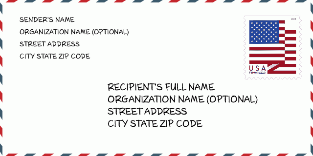
Адрес Пример
ARLINGTON NE 68002-5113
UNITED STATES OF AMERICA
68002-5113 Пример конверта

-
Это пример конверта США. Введите информацию об отправителе в верхнем левом углу и информацию о получателе в правом нижнем углу. Необходимая информация - полное имя отправителя / получателя, почтовый адрес, город, штат и почтовый индекс. Информация об адресе получателя предоставлена для справки. Как правило, если вы не уверены в полном 9-значном почтовом индексе, вы можете ввести только 5-значный почтовый индекс, чтобы избежать потери посылки.
68002-5113 Основное значение
-
Что означает каждая цифра почтового индекса 68002-5113? Индекс ZIP + 4 состоит из двух частей, первые пять цифр могут быть указаны для почтового отделения, а последние четыре цифры могут идентифицировать географический сегмент в пределах пятизначной зоны доставки. Цифры 6-7 обозначают сектор или несколько кварталов, а цифры 8-9 обозначают сегмент или одну сторону улицы.
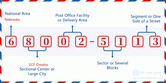

- ·Путь перевозки ID?
A 4-digit code assigned to a mail delivery or collection route within a 5-digit ZIP Code. The first character of this identification is alphabetical, and the last three are numeric: Bnnn = PO box Hnnn = Highway contract Rnnn = Rural route Cnnn = City delivery Gnnn = General delivery: R001 (Сельский маршрут )
- ·ZIP Add-On низкая часть ?
The ZIP Add-On Low Sector and the ZIP Add-On Low Segment together form the ZIP Add-On Low Number. The ZIP Add-On Low Number is the last four positions of a ZIP+4 code; the low-end ZIP add-on in a range of codes; the add-on of the first ZIP+4 code in a consecutive series of ZIP+4 codes assigned to the delivery address. For example, most delivery addresses are assigned a single ZIP+4 code. However, large companies may be given a range of ZIP+4 codes that can be used to route mail to specific departments. A range of ZIP+4 codes can also be assigned to a corresponding range of post office boxes, and each box is mapped, one-to-one, with a ZIP+4 code in the range. A single post office box can also be assigned a range of ZIP+4 codes.: 51
- ·ZIP Add-On низский сегмент ?
The ZIP Add-On Low Sector and the ZIP Add-On Low Segment together form the ZIP Add-On Low Number. The ZIP Add-On Low Number is the last four positions of a ZIP+4 code; the low-end ZIP add-on in a range of codes; the add-on of the first ZIP+4 code in a consecutive series of ZIP+4 codes assigned to the delivery address. For example, most delivery addresses are assigned a single ZIP+4 code. However, large companies may be given a range of ZIP+4 codes that can be used to route mail to specific departments. A range of ZIP+4 codes can also be assigned to a corresponding range of post office boxes, and each box is mapped, one-to-one, with a ZIP+4 code in the range. A single post office box can also be assigned a range of ZIP+4 codes.: 13
- ·ZIP Add-On высокая часть ?
The ZIP Add-On High Sector and the ZIP Add-On High Segment together form the ZIP Add-On High Number, which is the high-end ZIP add-on in a range of codes; the add-on of the last ZIP+4 code in a consecutive series of ZIP+4 codes assigned to the delivery address. Most delivery addresses are assigned a single ZIP+4 code; however, large companies may be given a range of ZIP+4 codes that can be used to route mail to specific departments. A range of ZIP+4 codes can also be assigned to a corresponding range of post office boxes, and each box is mapped, one-to-one, with a ZIP+4 code in the range. A single post office box can also be assigned a range of ZIP+4 codes. (See also ZIP Add-On Code.): 51
- ·ZIP Add-On высокий сегмент ?
The ZIP Add-On High Sector and the ZIP Add-On High Segment together form the ZIP Add-On High Number, which is the high-end ZIP add-on in a range of codes; the add-on of the last ZIP+4 code in a consecutive series of ZIP+4 codes assigned to the delivery address. Most delivery addresses are assigned a single ZIP+4 code; however, large companies may be given a range of ZIP+4 codes that can be used to route mail to specific departments. A range of ZIP+4 codes can also be assigned to a corresponding range of post office boxes, and each box is mapped, one-to-one, with a ZIP+4 code in the range. A single post office box can also be assigned a range of ZIP+4 codes. (See also ZIP Add-On Code.): 13
- ·Почтовый Индекс Добавить на : 5113
- ·Диапазон?
The range of +4 codes. Summing the +4 Code and the +4 Range will give you the high end of the range of +4 Codes that pertain to this ZIP Code.: 0
- ·Основной код для замены ?
Code that specifies whether a record is a base (preferred) or alternate record. Base records (represented as "B") can represent a range of addresses or an individual address, such as a firm record, while alternate records (represented as "A") are individual delivery points. Government deliveries will only be listed on alternate records with the appropriate government building indicator (federal, state, or city) set.: Основа
- ·Финансовое число ?
A code assigned to Postal Service facilities (primarily post offices) to collect cost and statistical data and compile revenue and expense data. The state number comprises the first two positions of the finance number.: 300405
- ·Парламентский номер зоны ?
A standard value identifying a geographic area within the United States served by a member of the US House of Representatives or Senate. If Army/Air Force (APO) or fleet post office (FPO), this column will be blank. If there is only one member of Congress within a state, the code will be "AL" (at large).: 01
- ·Код области города последней линии ?
An index to the City State file that provides the preferred last-line name for this address range.: W19465
Карта интернета

Это адрес 20300 COUNTY ROAD 26 ARLINGTON согласованная онлайновая электронная карта. Вы можете кнопкой в карте передвигать, пантографировать. Информация этой карты только для справки.
Адрес: 20300 (From 20300 To 20399) COUNTY ROAD 26, ARLINGTON, NE 68002-5113, USA
Комментарий


Добавить комментарий