عنوان: 20500 (From 20500 To 20599) COUNTY ROAD 28, ARLINGTON, NE 68002-5143, USA
ما هو 68002-5143؟ إنه 68002-5143هو 20500 (From 20500 To 20599) COUNTY ROAD 28, ARLINGTON, NE, USA 5 أضاف4 الرمز البريدي. معلومات التفاصيل علي نحو التالي.
68002-5143 معلومات اساسية

-
الرمز البريدي 5 زائد 4:
68002-5143 -
الرمز البريدي 5:
68002 -
بالإضافة إلى 4?51434-digits that are used to identify a geographic segment within the 5-digit delivery area, such as a city block or a group of apartments or an individual high-volume receiver of mail, or any other unit that could use an extra identifier to aid in efficient mail sorting and delivery. This code is the low end of the range of +4 Codes that pertain to this ZIP Code. ZIP+4 Codes associated with nondelivery areas are composed of valid ZIP sector numbers and "ND" for the ZIP segment number, for example 12345-12ND. Non-deliverable areas are areas to which the USPS does not deliver mail, such as vacant lots and land that borders railroad tracks. Mailers should not match an address identified as a nondelivery area. If you absolutely must have numeric characters in the Plus4Code column, you may treat "ND" values as "00" (zero zero).:
-
بلد:
U.S. - الولايات المتحدة -
حالة:
NE - نبراسكا -
مقاطعة:
CountyFIPS: 31177 - Washington County -
مدينة:
ARLINGTON -
شارع?COUNTY ROAD 28The official name of a street as assigned by a local governing authority. The Street Name column contains only the street name and does not include directionals (EAST, WEST, etc.) or suffixes (ST, DR, BLVD, etc.). This element may also contain literals, such as PO BOX, GENERAL DELIVERY, USS, PSC, or UNIT. Numeric street names that have numeric components that are four characters (or less) in length at are justified such that the low-order digit of the number is positioned in the fourth position of the street name column. This shift is made so that the numeric street names appear in numeric sequence.:
-
نوع السجل?S: شارعAn alphabetic value that identifies the type of data in the record. Record type codes include the following: G = General delivery H = Highrise F = Firm S = Street P = PO box R = Rural route/highway contract:
عنوان

- الرقم المنخفض من العنوان الرئيسي ?
A house, rural route, highway contract box, or post office box number; the numeric or alphanumeric component of an address preceding the street name; the low-end address in a range of addresses. Often referred to as house number.: 20500
- الرقم العالي من العنوان الرئيسي?
A house, rural route, contract box, or Post Office box number. The numeric or alphanumeric component of an address preceding the street name. The high-end address in a range of addresses. Often referred to as house number.: 20599
- رمز فردي من العنوان الرئيسي/رمز زوجي?
Code that identifies the side or sides of a street for which a given address range is applicable. For street, highrise, firm and multi-carrier records, B = Both sides of a street, E = Even side of a street (even-numbered addresses in the range); O = Odd side of a street (odd-numbered addresses in the range). For general delivery, post office box, and rural route/highway contract records, this code will always be "B" (both).: Both of Odd and Even
- ابتدائي نطاق: 20500, 20501, 20502, 20503, 20504, 20505, 20506, 20507, 20508, 20509, 20510, 20511, 20512, 20513, 20514, 20515, 20516, 20517, 20518, 20519, 20520, 20521, 20522, 20523, 20524, 20525, 20526, 20527, 20528, 20529, 20530, 20531, 20532, 20533, 20534, 20535, 20536, 20537, 20538, 20539, 20540, 20541, 20542, 20543, 20544, 20545, 20546, 20547, 20548, 20549, 20550, 20551, 20552, 20553, 20554, 20555, 20556, 20557, 20558, 20559, 20560, 20561, 20562, 20563, 20564, 20565, 20566, 20567, 20568, 20569, 20570, 20571, 20572, 20573, 20574, 20575, 20576, 20577, 20578, 20579, 20580, 20581, 20582, 20583, 20584, 20585, 20586, 20587, 20588, 20589, 20590, 20591, 20592, 20593, 20594, 20595, 20596, 20597, 20598, 20599.
الرجاء النقر فوق "المزيد من أمثلة العنوان" لعرض القائمة بأكملها.
20500 COUNTY ROAD 28, ARLINGTON, NE 68002-5143
20501 COUNTY ROAD 28, ARLINGTON, NE 68002-5143
20502 COUNTY ROAD 28, ARLINGTON, NE 68002-5143
20503 COUNTY ROAD 28, ARLINGTON, NE 68002-5143
20504 COUNTY ROAD 28, ARLINGTON, NE 68002-5143
20505 COUNTY ROAD 28, ARLINGTON, NE 68002-5143
20506 COUNTY ROAD 28, ARLINGTON, NE 68002-5143
20507 COUNTY ROAD 28, ARLINGTON, NE 68002-5143
20508 COUNTY ROAD 28, ARLINGTON, NE 68002-5143
20509 COUNTY ROAD 28, ARLINGTON, NE 68002-5143
20510 COUNTY ROAD 28, ARLINGTON, NE 68002-5143
20511 COUNTY ROAD 28, ARLINGTON, NE 68002-5143
20512 COUNTY ROAD 28, ARLINGTON, NE 68002-5143
20513 COUNTY ROAD 28, ARLINGTON, NE 68002-5143
20514 COUNTY ROAD 28, ARLINGTON, NE 68002-5143
20515 COUNTY ROAD 28, ARLINGTON, NE 68002-5143
20516 COUNTY ROAD 28, ARLINGTON, NE 68002-5143
20517 COUNTY ROAD 28, ARLINGTON, NE 68002-5143
20518 COUNTY ROAD 28, ARLINGTON, NE 68002-5143
20519 COUNTY ROAD 28, ARLINGTON, NE 68002-5143
20520 COUNTY ROAD 28, ARLINGTON, NE 68002-5143
20521 COUNTY ROAD 28, ARLINGTON, NE 68002-5143
20522 COUNTY ROAD 28, ARLINGTON, NE 68002-5143
20523 COUNTY ROAD 28, ARLINGTON, NE 68002-5143
20524 COUNTY ROAD 28, ARLINGTON, NE 68002-5143
20525 COUNTY ROAD 28, ARLINGTON, NE 68002-5143
20526 COUNTY ROAD 28, ARLINGTON, NE 68002-5143
20527 COUNTY ROAD 28, ARLINGTON, NE 68002-5143
20528 COUNTY ROAD 28, ARLINGTON, NE 68002-5143
20529 COUNTY ROAD 28, ARLINGTON, NE 68002-5143
20530 COUNTY ROAD 28, ARLINGTON, NE 68002-5143
20531 COUNTY ROAD 28, ARLINGTON, NE 68002-5143
20532 COUNTY ROAD 28, ARLINGTON, NE 68002-5143
20533 COUNTY ROAD 28, ARLINGTON, NE 68002-5143
20534 COUNTY ROAD 28, ARLINGTON, NE 68002-5143
20535 COUNTY ROAD 28, ARLINGTON, NE 68002-5143
20536 COUNTY ROAD 28, ARLINGTON, NE 68002-5143
20537 COUNTY ROAD 28, ARLINGTON, NE 68002-5143
20538 COUNTY ROAD 28, ARLINGTON, NE 68002-5143
20539 COUNTY ROAD 28, ARLINGTON, NE 68002-5143
20540 COUNTY ROAD 28, ARLINGTON, NE 68002-5143
20541 COUNTY ROAD 28, ARLINGTON, NE 68002-5143
20542 COUNTY ROAD 28, ARLINGTON, NE 68002-5143
20543 COUNTY ROAD 28, ARLINGTON, NE 68002-5143
20544 COUNTY ROAD 28, ARLINGTON, NE 68002-5143
20545 COUNTY ROAD 28, ARLINGTON, NE 68002-5143
20546 COUNTY ROAD 28, ARLINGTON, NE 68002-5143
20547 COUNTY ROAD 28, ARLINGTON, NE 68002-5143
20548 COUNTY ROAD 28, ARLINGTON, NE 68002-5143
20549 COUNTY ROAD 28, ARLINGTON, NE 68002-5143
20550 COUNTY ROAD 28, ARLINGTON, NE 68002-5143
20551 COUNTY ROAD 28, ARLINGTON, NE 68002-5143
20552 COUNTY ROAD 28, ARLINGTON, NE 68002-5143
20553 COUNTY ROAD 28, ARLINGTON, NE 68002-5143
20554 COUNTY ROAD 28, ARLINGTON, NE 68002-5143
20555 COUNTY ROAD 28, ARLINGTON, NE 68002-5143
20556 COUNTY ROAD 28, ARLINGTON, NE 68002-5143
20557 COUNTY ROAD 28, ARLINGTON, NE 68002-5143
20558 COUNTY ROAD 28, ARLINGTON, NE 68002-5143
20559 COUNTY ROAD 28, ARLINGTON, NE 68002-5143
20560 COUNTY ROAD 28, ARLINGTON, NE 68002-5143
20561 COUNTY ROAD 28, ARLINGTON, NE 68002-5143
20562 COUNTY ROAD 28, ARLINGTON, NE 68002-5143
20563 COUNTY ROAD 28, ARLINGTON, NE 68002-5143
20564 COUNTY ROAD 28, ARLINGTON, NE 68002-5143
20565 COUNTY ROAD 28, ARLINGTON, NE 68002-5143
20566 COUNTY ROAD 28, ARLINGTON, NE 68002-5143
20567 COUNTY ROAD 28, ARLINGTON, NE 68002-5143
20568 COUNTY ROAD 28, ARLINGTON, NE 68002-5143
20569 COUNTY ROAD 28, ARLINGTON, NE 68002-5143
20570 COUNTY ROAD 28, ARLINGTON, NE 68002-5143
20571 COUNTY ROAD 28, ARLINGTON, NE 68002-5143
20572 COUNTY ROAD 28, ARLINGTON, NE 68002-5143
20573 COUNTY ROAD 28, ARLINGTON, NE 68002-5143
20574 COUNTY ROAD 28, ARLINGTON, NE 68002-5143
20575 COUNTY ROAD 28, ARLINGTON, NE 68002-5143
20576 COUNTY ROAD 28, ARLINGTON, NE 68002-5143
20577 COUNTY ROAD 28, ARLINGTON, NE 68002-5143
20578 COUNTY ROAD 28, ARLINGTON, NE 68002-5143
20579 COUNTY ROAD 28, ARLINGTON, NE 68002-5143
20580 COUNTY ROAD 28, ARLINGTON, NE 68002-5143
20581 COUNTY ROAD 28, ARLINGTON, NE 68002-5143
20582 COUNTY ROAD 28, ARLINGTON, NE 68002-5143
20583 COUNTY ROAD 28, ARLINGTON, NE 68002-5143
20584 COUNTY ROAD 28, ARLINGTON, NE 68002-5143
20585 COUNTY ROAD 28, ARLINGTON, NE 68002-5143
20586 COUNTY ROAD 28, ARLINGTON, NE 68002-5143
20587 COUNTY ROAD 28, ARLINGTON, NE 68002-5143
20588 COUNTY ROAD 28, ARLINGTON, NE 68002-5143
20589 COUNTY ROAD 28, ARLINGTON, NE 68002-5143
20590 COUNTY ROAD 28, ARLINGTON, NE 68002-5143
20591 COUNTY ROAD 28, ARLINGTON, NE 68002-5143
20592 COUNTY ROAD 28, ARLINGTON, NE 68002-5143
20593 COUNTY ROAD 28, ARLINGTON, NE 68002-5143
20594 COUNTY ROAD 28, ARLINGTON, NE 68002-5143
20595 COUNTY ROAD 28, ARLINGTON, NE 68002-5143
20596 COUNTY ROAD 28, ARLINGTON, NE 68002-5143
20597 COUNTY ROAD 28, ARLINGTON, NE 68002-5143
20598 COUNTY ROAD 28, ARLINGTON, NE 68002-5143
20599 COUNTY ROAD 28, ARLINGTON, NE 68002-5143
عنوان مثال
ARLINGTON NE 68002-5143
UNITED STATES OF AMERICA
68002-5143 مثال المغلف

-
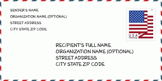
هذا مثال على مغلف الولايات المتحدة. املأ معلومات المرسل في أعلى اليسار ومعلومات المستلم في أسفل اليمين. المعلومات الضرورية هي الاسم الكامل للمرسل / المستلم وعنوان الشارع والمدينة والولاية والرمز البريدي. تم تقديم معلومات عنوان المستلم كمرجع لك. بشكل عام ، إذا لم تكن متأكدًا من الرمز البريدي الكامل المكون من 9 أرقام ، فيمكنك فقط ملء الرمز البريدي المكون من 5 أرقام لتجنب فقد الحزمة.
68002-5143 المعنى الأساسي
-
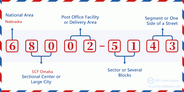
ما الذي يرمز إليه كل رقم في الرمز البريدي 68002-5143؟ يتكون الرمز البريدي + 4 من جزأين ، يمكن تحديد موقع أول خمسة أرقام في مكتب البريد ، ويمكن للأرقام الأربعة الأخيرة تحديد مقطع جغرافي داخل منطقة التسليم المكونة من خمسة أرقام. تحدد الأرقام المكونة من 6 إلى 7 أرقام قطاعًا أو عدة كتل ، بينما تحدد الأرقام المكونة من 8 إلى 9 أرقام مقطعًا أو جانبًا واحدًا من الشارع.

- ·طرق النقل ID?
A 4-digit code assigned to a mail delivery or collection route within a 5-digit ZIP Code. The first character of this identification is alphabetical, and the last three are numeric: Bnnn = PO box Hnnn = Highway contract Rnnn = Rural route Cnnn = City delivery Gnnn = General delivery: R001 (المسار الريفية)
- ·أضاف البريد علي قطاع منخفضة?
The ZIP Add-On Low Sector and the ZIP Add-On Low Segment together form the ZIP Add-On Low Number. The ZIP Add-On Low Number is the last four positions of a ZIP+4 code; the low-end ZIP add-on in a range of codes; the add-on of the first ZIP+4 code in a consecutive series of ZIP+4 codes assigned to the delivery address. For example, most delivery addresses are assigned a single ZIP+4 code. However, large companies may be given a range of ZIP+4 codes that can be used to route mail to specific departments. A range of ZIP+4 codes can also be assigned to a corresponding range of post office boxes, and each box is mapped, one-to-one, with a ZIP+4 code in the range. A single post office box can also be assigned a range of ZIP+4 codes.: 51
- ·أضاف البريد علي جزء منخفضة?
The ZIP Add-On Low Sector and the ZIP Add-On Low Segment together form the ZIP Add-On Low Number. The ZIP Add-On Low Number is the last four positions of a ZIP+4 code; the low-end ZIP add-on in a range of codes; the add-on of the first ZIP+4 code in a consecutive series of ZIP+4 codes assigned to the delivery address. For example, most delivery addresses are assigned a single ZIP+4 code. However, large companies may be given a range of ZIP+4 codes that can be used to route mail to specific departments. A range of ZIP+4 codes can also be assigned to a corresponding range of post office boxes, and each box is mapped, one-to-one, with a ZIP+4 code in the range. A single post office box can also be assigned a range of ZIP+4 codes.: 43
- ·أضاف البريد علي قطاع عالية?
The ZIP Add-On High Sector and the ZIP Add-On High Segment together form the ZIP Add-On High Number, which is the high-end ZIP add-on in a range of codes; the add-on of the last ZIP+4 code in a consecutive series of ZIP+4 codes assigned to the delivery address. Most delivery addresses are assigned a single ZIP+4 code; however, large companies may be given a range of ZIP+4 codes that can be used to route mail to specific departments. A range of ZIP+4 codes can also be assigned to a corresponding range of post office boxes, and each box is mapped, one-to-one, with a ZIP+4 code in the range. A single post office box can also be assigned a range of ZIP+4 codes. (See also ZIP Add-On Code.): 51
- ·أضاف البريد علي جزء عالية?
The ZIP Add-On High Sector and the ZIP Add-On High Segment together form the ZIP Add-On High Number, which is the high-end ZIP add-on in a range of codes; the add-on of the last ZIP+4 code in a consecutive series of ZIP+4 codes assigned to the delivery address. Most delivery addresses are assigned a single ZIP+4 code; however, large companies may be given a range of ZIP+4 codes that can be used to route mail to specific departments. A range of ZIP+4 codes can also be assigned to a corresponding range of post office boxes, and each box is mapped, one-to-one, with a ZIP+4 code in the range. A single post office box can also be assigned a range of ZIP+4 codes. (See also ZIP Add-On Code.): 43
- ·الرمز البريدي ملحق: 5143
- ·نطاق?
The range of +4 codes. Summing the +4 Code and the +4 Range will give you the high end of the range of +4 Codes that pertain to this ZIP Code.: 0
- ·رمز البديل الأساسي?
Code that specifies whether a record is a base (preferred) or alternate record. Base records (represented as "B") can represent a range of addresses or an individual address, such as a firm record, while alternate records (represented as "A") are individual delivery points. Government deliveries will only be listed on alternate records with the appropriate government building indicator (federal, state, or city) set.: قاعدة
- ·الأرقام المالية?
A code assigned to Postal Service facilities (primarily post offices) to collect cost and statistical data and compile revenue and expense data. The state number comprises the first two positions of the finance number.: 300405
- ·رقم منطقة الكونغرس?
A standard value identifying a geographic area within the United States served by a member of the US House of Representatives or Senate. If Army/Air Force (APO) or fleet post office (FPO), this column will be blank. If there is only one member of Congress within a state, the code will be "AL" (at large).: 01
- ·رمز المدينة المفضلة الأخير?
An index to the City State file that provides the preferred last-line name for this address range.: W19465
خريطة الانترنت

هذا هو عنوان 20500 COUNTY ROAD 28 ARLINGTON مطابقة الخريطة الإلكترونية عبر الإنترنت يمكنك استخدام زر في الخريطة للتحرك وتكبير. معلومات الخريطة هي للإشارة فقط.
عنوان: 20500 (From 20500 To 20599) COUNTY ROAD 28, ARLINGTON, NE 68002-5143, USA
التعليق


إضافة تعليق جديد