نشانی: 600 (From 600 To 699) COUNTY ROAD 18, CERESCO, NE 68017-4043, USA
؟68017-4043 چیست 68017-4043 یک کد فشرده 5 به همراه 4 عدد از 600 (From 600 To 699) COUNTY ROAD 18, CERESCO, NE, USA است. اطلاعات بیشتر در زیر آمده است.
68017-4043 اطلاعات اولیه

-
کد پستی 5 به علاوه 4:
68017-4043 -
کد پستی 5:
68017 -
به علاوه 4?40434-digits that are used to identify a geographic segment within the 5-digit delivery area, such as a city block or a group of apartments or an individual high-volume receiver of mail, or any other unit that could use an extra identifier to aid in efficient mail sorting and delivery. This code is the low end of the range of +4 Codes that pertain to this ZIP Code. ZIP+4 Codes associated with nondelivery areas are composed of valid ZIP sector numbers and "ND" for the ZIP segment number, for example 12345-12ND. Non-deliverable areas are areas to which the USPS does not deliver mail, such as vacant lots and land that borders railroad tracks. Mailers should not match an address identified as a nondelivery area. If you absolutely must have numeric characters in the Plus4Code column, you may treat "ND" values as "00" (zero zero).:
-
کشور:
U.S. - ایالات متحده -
دولت:
NE - نبراسکا -
شهرستان:
CountyFIPS: 31155 - Saunders County -
شهر:
CERESCO -
خیابان?COUNTY ROAD 18The official name of a street as assigned by a local governing authority. The Street Name column contains only the street name and does not include directionals (EAST, WEST, etc.) or suffixes (ST, DR, BLVD, etc.). This element may also contain literals, such as PO BOX, GENERAL DELIVERY, USS, PSC, or UNIT. Numeric street names that have numeric components that are four characters (or less) in length at are justified such that the low-order digit of the number is positioned in the fourth position of the street name column. This shift is made so that the numeric street names appear in numeric sequence.:
-
نوع ثبت?S: خیابانAn alphabetic value that identifies the type of data in the record. Record type codes include the following: G = General delivery H = Highrise F = Firm S = Street P = PO box R = Rural route/highway contract:
نشانی

- شماره پایین آدرس اولیه?
A house, rural route, highway contract box, or post office box number; the numeric or alphanumeric component of an address preceding the street name; the low-end address in a range of addresses. Often referred to as house number.: 600
- شماره بالا آدرس اولیه?
A house, rural route, contract box, or Post Office box number. The numeric or alphanumeric component of an address preceding the street name. The high-end address in a range of addresses. Often referred to as house number.: 699
- کد فرد/ زوج آدرس اولیه?
Code that identifies the side or sides of a street for which a given address range is applicable. For street, highrise, firm and multi-carrier records, B = Both sides of a street, E = Even side of a street (even-numbered addresses in the range); O = Odd side of a street (odd-numbered addresses in the range). For general delivery, post office box, and rural route/highway contract records, this code will always be "B" (both).: Both of Odd and Even
- اولیه محدوده: 600, 601, 602, 603, 604, 605, 606, 607, 608, 609, 610, 611, 612, 613, 614, 615, 616, 617, 618, 619, 620, 621, 622, 623, 624, 625, 626, 627, 628, 629, 630, 631, 632, 633, 634, 635, 636, 637, 638, 639, 640, 641, 642, 643, 644, 645, 646, 647, 648, 649, 650, 651, 652, 653, 654, 655, 656, 657, 658, 659, 660, 661, 662, 663, 664, 665, 666, 667, 668, 669, 670, 671, 672, 673, 674, 675, 676, 677, 678, 679, 680, 681, 682, 683, 684, 685, 686, 687, 688, 689, 690, 691, 692, 693, 694, 695, 696, 697, 698, 699.
لطفاً برای مشاهده کل لیست ، بر روی "نمونه های آدرس بیشتر" کلیک کنید.
600 COUNTY ROAD 18, CERESCO, NE 68017-4043
601 COUNTY ROAD 18, CERESCO, NE 68017-4043
602 COUNTY ROAD 18, CERESCO, NE 68017-4043
603 COUNTY ROAD 18, CERESCO, NE 68017-4043
604 COUNTY ROAD 18, CERESCO, NE 68017-4043
605 COUNTY ROAD 18, CERESCO, NE 68017-4043
606 COUNTY ROAD 18, CERESCO, NE 68017-4043
607 COUNTY ROAD 18, CERESCO, NE 68017-4043
608 COUNTY ROAD 18, CERESCO, NE 68017-4043
609 COUNTY ROAD 18, CERESCO, NE 68017-4043
610 COUNTY ROAD 18, CERESCO, NE 68017-4043
611 COUNTY ROAD 18, CERESCO, NE 68017-4043
612 COUNTY ROAD 18, CERESCO, NE 68017-4043
613 COUNTY ROAD 18, CERESCO, NE 68017-4043
614 COUNTY ROAD 18, CERESCO, NE 68017-4043
615 COUNTY ROAD 18, CERESCO, NE 68017-4043
616 COUNTY ROAD 18, CERESCO, NE 68017-4043
617 COUNTY ROAD 18, CERESCO, NE 68017-4043
618 COUNTY ROAD 18, CERESCO, NE 68017-4043
619 COUNTY ROAD 18, CERESCO, NE 68017-4043
620 COUNTY ROAD 18, CERESCO, NE 68017-4043
621 COUNTY ROAD 18, CERESCO, NE 68017-4043
622 COUNTY ROAD 18, CERESCO, NE 68017-4043
623 COUNTY ROAD 18, CERESCO, NE 68017-4043
624 COUNTY ROAD 18, CERESCO, NE 68017-4043
625 COUNTY ROAD 18, CERESCO, NE 68017-4043
626 COUNTY ROAD 18, CERESCO, NE 68017-4043
627 COUNTY ROAD 18, CERESCO, NE 68017-4043
628 COUNTY ROAD 18, CERESCO, NE 68017-4043
629 COUNTY ROAD 18, CERESCO, NE 68017-4043
630 COUNTY ROAD 18, CERESCO, NE 68017-4043
631 COUNTY ROAD 18, CERESCO, NE 68017-4043
632 COUNTY ROAD 18, CERESCO, NE 68017-4043
633 COUNTY ROAD 18, CERESCO, NE 68017-4043
634 COUNTY ROAD 18, CERESCO, NE 68017-4043
635 COUNTY ROAD 18, CERESCO, NE 68017-4043
636 COUNTY ROAD 18, CERESCO, NE 68017-4043
637 COUNTY ROAD 18, CERESCO, NE 68017-4043
638 COUNTY ROAD 18, CERESCO, NE 68017-4043
639 COUNTY ROAD 18, CERESCO, NE 68017-4043
640 COUNTY ROAD 18, CERESCO, NE 68017-4043
641 COUNTY ROAD 18, CERESCO, NE 68017-4043
642 COUNTY ROAD 18, CERESCO, NE 68017-4043
643 COUNTY ROAD 18, CERESCO, NE 68017-4043
644 COUNTY ROAD 18, CERESCO, NE 68017-4043
645 COUNTY ROAD 18, CERESCO, NE 68017-4043
646 COUNTY ROAD 18, CERESCO, NE 68017-4043
647 COUNTY ROAD 18, CERESCO, NE 68017-4043
648 COUNTY ROAD 18, CERESCO, NE 68017-4043
649 COUNTY ROAD 18, CERESCO, NE 68017-4043
650 COUNTY ROAD 18, CERESCO, NE 68017-4043
651 COUNTY ROAD 18, CERESCO, NE 68017-4043
652 COUNTY ROAD 18, CERESCO, NE 68017-4043
653 COUNTY ROAD 18, CERESCO, NE 68017-4043
654 COUNTY ROAD 18, CERESCO, NE 68017-4043
655 COUNTY ROAD 18, CERESCO, NE 68017-4043
656 COUNTY ROAD 18, CERESCO, NE 68017-4043
657 COUNTY ROAD 18, CERESCO, NE 68017-4043
658 COUNTY ROAD 18, CERESCO, NE 68017-4043
659 COUNTY ROAD 18, CERESCO, NE 68017-4043
660 COUNTY ROAD 18, CERESCO, NE 68017-4043
661 COUNTY ROAD 18, CERESCO, NE 68017-4043
662 COUNTY ROAD 18, CERESCO, NE 68017-4043
663 COUNTY ROAD 18, CERESCO, NE 68017-4043
664 COUNTY ROAD 18, CERESCO, NE 68017-4043
665 COUNTY ROAD 18, CERESCO, NE 68017-4043
666 COUNTY ROAD 18, CERESCO, NE 68017-4043
667 COUNTY ROAD 18, CERESCO, NE 68017-4043
668 COUNTY ROAD 18, CERESCO, NE 68017-4043
669 COUNTY ROAD 18, CERESCO, NE 68017-4043
670 COUNTY ROAD 18, CERESCO, NE 68017-4043
671 COUNTY ROAD 18, CERESCO, NE 68017-4043
672 COUNTY ROAD 18, CERESCO, NE 68017-4043
673 COUNTY ROAD 18, CERESCO, NE 68017-4043
674 COUNTY ROAD 18, CERESCO, NE 68017-4043
675 COUNTY ROAD 18, CERESCO, NE 68017-4043
676 COUNTY ROAD 18, CERESCO, NE 68017-4043
677 COUNTY ROAD 18, CERESCO, NE 68017-4043
678 COUNTY ROAD 18, CERESCO, NE 68017-4043
679 COUNTY ROAD 18, CERESCO, NE 68017-4043
680 COUNTY ROAD 18, CERESCO, NE 68017-4043
681 COUNTY ROAD 18, CERESCO, NE 68017-4043
682 COUNTY ROAD 18, CERESCO, NE 68017-4043
683 COUNTY ROAD 18, CERESCO, NE 68017-4043
684 COUNTY ROAD 18, CERESCO, NE 68017-4043
685 COUNTY ROAD 18, CERESCO, NE 68017-4043
686 COUNTY ROAD 18, CERESCO, NE 68017-4043
687 COUNTY ROAD 18, CERESCO, NE 68017-4043
688 COUNTY ROAD 18, CERESCO, NE 68017-4043
689 COUNTY ROAD 18, CERESCO, NE 68017-4043
690 COUNTY ROAD 18, CERESCO, NE 68017-4043
691 COUNTY ROAD 18, CERESCO, NE 68017-4043
692 COUNTY ROAD 18, CERESCO, NE 68017-4043
693 COUNTY ROAD 18, CERESCO, NE 68017-4043
694 COUNTY ROAD 18, CERESCO, NE 68017-4043
695 COUNTY ROAD 18, CERESCO, NE 68017-4043
696 COUNTY ROAD 18, CERESCO, NE 68017-4043
697 COUNTY ROAD 18, CERESCO, NE 68017-4043
698 COUNTY ROAD 18, CERESCO, NE 68017-4043
699 COUNTY ROAD 18, CERESCO, NE 68017-4043
نشانی مثال
CERESCO NE 68017-4043
UNITED STATES OF AMERICA
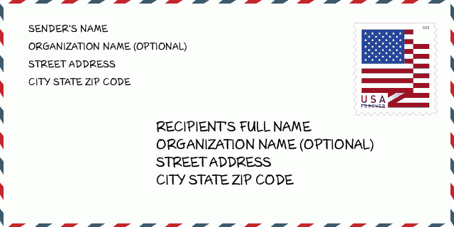
68017-4043 نمونه پاکت

-
این نمونه ای از پاکت نامه ایالات متحده است. اطلاعات فرستنده را در بالا سمت چپ و اطلاعات گیرنده را در پایین سمت راست وارد کنید. اطلاعات لازم نام کامل فرستنده/گیرنده ، آدرس خیابان ، شهر ، ایالت و کد پستی است. اطلاعات آدرس گیرنده برای مرجع شما داده شده است. به طور کلی ، اگر از کد پستی کامل 9 رقمی مطمئن نیستید ، فقط می توانید کد پستی 5 رقمی را پر کنید تا از دست دادن بسته جلوگیری شود.
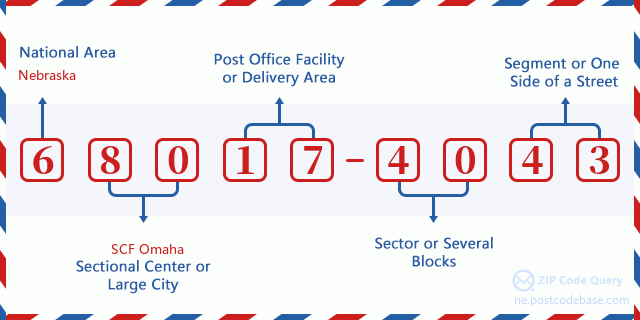
68017-4043 معنای اساسی
-
هر رقم کد پستی 68017-4043 مخفف چیست؟ کد ZIP+4 از دو بخش تشکیل شده است، پنج رقم اول را می توان در اداره پست قرار داد، و چهار رقم آخر می تواند یک بخش جغرافیایی را در منطقه تحویل پنج رقمی مشخص کند. 6-7 رقم بخش یا چند بلوک را مشخص می کند و رقم 8-9 نشان دهنده بخش یا یک طرف خیابان است.

- ·شناسایی مسیر حامل?
A 4-digit code assigned to a mail delivery or collection route within a 5-digit ZIP Code. The first character of this identification is alphabetical, and the last three are numeric: Bnnn = PO box Hnnn = Highway contract Rnnn = Rural route Cnnn = City delivery Gnnn = General delivery: R001 (مسیر روستایی)
- ·بخش پایین افزونه فشرده?
The ZIP Add-On Low Sector and the ZIP Add-On Low Segment together form the ZIP Add-On Low Number. The ZIP Add-On Low Number is the last four positions of a ZIP+4 code; the low-end ZIP add-on in a range of codes; the add-on of the first ZIP+4 code in a consecutive series of ZIP+4 codes assigned to the delivery address. For example, most delivery addresses are assigned a single ZIP+4 code. However, large companies may be given a range of ZIP+4 codes that can be used to route mail to specific departments. A range of ZIP+4 codes can also be assigned to a corresponding range of post office boxes, and each box is mapped, one-to-one, with a ZIP+4 code in the range. A single post office box can also be assigned a range of ZIP+4 codes.: 40
- ·بخش پایین افزونه فشرده?
The ZIP Add-On Low Sector and the ZIP Add-On Low Segment together form the ZIP Add-On Low Number. The ZIP Add-On Low Number is the last four positions of a ZIP+4 code; the low-end ZIP add-on in a range of codes; the add-on of the first ZIP+4 code in a consecutive series of ZIP+4 codes assigned to the delivery address. For example, most delivery addresses are assigned a single ZIP+4 code. However, large companies may be given a range of ZIP+4 codes that can be used to route mail to specific departments. A range of ZIP+4 codes can also be assigned to a corresponding range of post office boxes, and each box is mapped, one-to-one, with a ZIP+4 code in the range. A single post office box can also be assigned a range of ZIP+4 codes.: 43
- ·بخش بالا افزونه فشرده?
The ZIP Add-On High Sector and the ZIP Add-On High Segment together form the ZIP Add-On High Number, which is the high-end ZIP add-on in a range of codes; the add-on of the last ZIP+4 code in a consecutive series of ZIP+4 codes assigned to the delivery address. Most delivery addresses are assigned a single ZIP+4 code; however, large companies may be given a range of ZIP+4 codes that can be used to route mail to specific departments. A range of ZIP+4 codes can also be assigned to a corresponding range of post office boxes, and each box is mapped, one-to-one, with a ZIP+4 code in the range. A single post office box can also be assigned a range of ZIP+4 codes. (See also ZIP Add-On Code.): 40
- ·بخش بالا افزونه فشرده?
The ZIP Add-On High Sector and the ZIP Add-On High Segment together form the ZIP Add-On High Number, which is the high-end ZIP add-on in a range of codes; the add-on of the last ZIP+4 code in a consecutive series of ZIP+4 codes assigned to the delivery address. Most delivery addresses are assigned a single ZIP+4 code; however, large companies may be given a range of ZIP+4 codes that can be used to route mail to specific departments. A range of ZIP+4 codes can also be assigned to a corresponding range of post office boxes, and each box is mapped, one-to-one, with a ZIP+4 code in the range. A single post office box can also be assigned a range of ZIP+4 codes. (See also ZIP Add-On Code.): 43
- ·کد پستی افزونه: 4043
- ·محدوده?
The range of +4 codes. Summing the +4 Code and the +4 Range will give you the high end of the range of +4 Codes that pertain to this ZIP Code.: 0
- ·کد متناوب پایه?
Code that specifies whether a record is a base (preferred) or alternate record. Base records (represented as "B") can represent a range of addresses or an individual address, such as a firm record, while alternate records (represented as "A") are individual delivery points. Government deliveries will only be listed on alternate records with the appropriate government building indicator (federal, state, or city) set.: پایه
- ·شماره مالی?
A code assigned to Postal Service facilities (primarily post offices) to collect cost and statistical data and compile revenue and expense data. The state number comprises the first two positions of the finance number.: 301740
- ·شماره ناحیه کنگره?
A standard value identifying a geographic area within the United States served by a member of the US House of Representatives or Senate. If Army/Air Force (APO) or fleet post office (FPO), this column will be blank. If there is only one member of Congress within a state, the code will be "AL" (at large).: 01
- ·کلید دولتی خط نهایی ترجیحی?
An index to the City State file that provides the preferred last-line name for this address range.: W19596
نقشه آنلاین

این نقشه آنلاین آدرس 600 COUNTY ROAD 18 CERESCO است. برای حرکت و زوم میتوانید از دکمه استفاده کنید. اطلاعات نقشه تنها برای مرجع است.
نشانی: 600 (From 600 To 699) COUNTY ROAD 18, CERESCO, NE 68017-4043, USA
دیدگاه


افزودن دیدگاه جدید