Cím: 19800 (From 19800 To 19899) COUNTY ROAD 26, ARLINGTON, NE 68002-5114, USA
Mi az 68002-5114? 68002-5114 az 19800 (From 19800 To 19899) COUNTY ROAD 26, ARLINGTON, NE, USA 5 jegyü irányitószám plusz 4 számjegy.Alábbiakban részletes információért.
68002-5114 Alapinformációk

-
Irányítószám 5 Plus 4:
68002-5114 -
Irányítószám 5:
68002 -
Plus 4?51144-digits that are used to identify a geographic segment within the 5-digit delivery area, such as a city block or a group of apartments or an individual high-volume receiver of mail, or any other unit that could use an extra identifier to aid in efficient mail sorting and delivery. This code is the low end of the range of +4 Codes that pertain to this ZIP Code. ZIP+4 Codes associated with nondelivery areas are composed of valid ZIP sector numbers and "ND" for the ZIP segment number, for example 12345-12ND. Non-deliverable areas are areas to which the USPS does not deliver mail, such as vacant lots and land that borders railroad tracks. Mailers should not match an address identified as a nondelivery area. If you absolutely must have numeric characters in the Plus4Code column, you may treat "ND" values as "00" (zero zero).:
-
Ország:
U.S. - Egyesült Államok -
Állam:
NE - Nebraska -
Megye:
CountyFIPS: 31177 - Washington County -
Város:
ARLINGTON -
Utca?COUNTY ROAD 26The official name of a street as assigned by a local governing authority. The Street Name column contains only the street name and does not include directionals (EAST, WEST, etc.) or suffixes (ST, DR, BLVD, etc.). This element may also contain literals, such as PO BOX, GENERAL DELIVERY, USS, PSC, or UNIT. Numeric street names that have numeric components that are four characters (or less) in length at are justified such that the low-order digit of the number is positioned in the fourth position of the street name column. This shift is made so that the numeric street names appear in numeric sequence.:
-
Rekord Típus?S: UtcaAn alphabetic value that identifies the type of data in the record. Record type codes include the following: G = General delivery H = Highrise F = Firm S = Street P = PO box R = Rural route/highway contract:
Cím

- Elsődleges Cím Alacsony Szám?
A house, rural route, highway contract box, or post office box number; the numeric or alphanumeric component of an address preceding the street name; the low-end address in a range of addresses. Often referred to as house number.: 19800
- Elsődleges Cím Magas Szám?
A house, rural route, contract box, or Post Office box number. The numeric or alphanumeric component of an address preceding the street name. The high-end address in a range of addresses. Often referred to as house number.: 19899
- Elsődleges Cím Páros / Páratlan Kód?
Code that identifies the side or sides of a street for which a given address range is applicable. For street, highrise, firm and multi-carrier records, B = Both sides of a street, E = Even side of a street (even-numbered addresses in the range); O = Odd side of a street (odd-numbered addresses in the range). For general delivery, post office box, and rural route/highway contract records, this code will always be "B" (both).: Both of Odd and Even
- Elsődleges Sorozat: 19800, 19801, 19802, 19803, 19804, 19805, 19806, 19807, 19808, 19809, 19810, 19811, 19812, 19813, 19814, 19815, 19816, 19817, 19818, 19819, 19820, 19821, 19822, 19823, 19824, 19825, 19826, 19827, 19828, 19829, 19830, 19831, 19832, 19833, 19834, 19835, 19836, 19837, 19838, 19839, 19840, 19841, 19842, 19843, 19844, 19845, 19846, 19847, 19848, 19849, 19850, 19851, 19852, 19853, 19854, 19855, 19856, 19857, 19858, 19859, 19860, 19861, 19862, 19863, 19864, 19865, 19866, 19867, 19868, 19869, 19870, 19871, 19872, 19873, 19874, 19875, 19876, 19877, 19878, 19879, 19880, 19881, 19882, 19883, 19884, 19885, 19886, 19887, 19888, 19889, 19890, 19891, 19892, 19893, 19894, 19895, 19896, 19897, 19898, 19899.
A teljes lista megtekintéséhez kattintson a "További címpéldák"-re.
19800 COUNTY ROAD 26, ARLINGTON, NE 68002-5114
19801 COUNTY ROAD 26, ARLINGTON, NE 68002-5114
19802 COUNTY ROAD 26, ARLINGTON, NE 68002-5114
19803 COUNTY ROAD 26, ARLINGTON, NE 68002-5114
19804 COUNTY ROAD 26, ARLINGTON, NE 68002-5114
19805 COUNTY ROAD 26, ARLINGTON, NE 68002-5114
19806 COUNTY ROAD 26, ARLINGTON, NE 68002-5114
19807 COUNTY ROAD 26, ARLINGTON, NE 68002-5114
19808 COUNTY ROAD 26, ARLINGTON, NE 68002-5114
19809 COUNTY ROAD 26, ARLINGTON, NE 68002-5114
19810 COUNTY ROAD 26, ARLINGTON, NE 68002-5114
19811 COUNTY ROAD 26, ARLINGTON, NE 68002-5114
19812 COUNTY ROAD 26, ARLINGTON, NE 68002-5114
19813 COUNTY ROAD 26, ARLINGTON, NE 68002-5114
19814 COUNTY ROAD 26, ARLINGTON, NE 68002-5114
19815 COUNTY ROAD 26, ARLINGTON, NE 68002-5114
19816 COUNTY ROAD 26, ARLINGTON, NE 68002-5114
19817 COUNTY ROAD 26, ARLINGTON, NE 68002-5114
19818 COUNTY ROAD 26, ARLINGTON, NE 68002-5114
19819 COUNTY ROAD 26, ARLINGTON, NE 68002-5114
19820 COUNTY ROAD 26, ARLINGTON, NE 68002-5114
19821 COUNTY ROAD 26, ARLINGTON, NE 68002-5114
19822 COUNTY ROAD 26, ARLINGTON, NE 68002-5114
19823 COUNTY ROAD 26, ARLINGTON, NE 68002-5114
19824 COUNTY ROAD 26, ARLINGTON, NE 68002-5114
19825 COUNTY ROAD 26, ARLINGTON, NE 68002-5114
19826 COUNTY ROAD 26, ARLINGTON, NE 68002-5114
19827 COUNTY ROAD 26, ARLINGTON, NE 68002-5114
19828 COUNTY ROAD 26, ARLINGTON, NE 68002-5114
19829 COUNTY ROAD 26, ARLINGTON, NE 68002-5114
19830 COUNTY ROAD 26, ARLINGTON, NE 68002-5114
19831 COUNTY ROAD 26, ARLINGTON, NE 68002-5114
19832 COUNTY ROAD 26, ARLINGTON, NE 68002-5114
19833 COUNTY ROAD 26, ARLINGTON, NE 68002-5114
19834 COUNTY ROAD 26, ARLINGTON, NE 68002-5114
19835 COUNTY ROAD 26, ARLINGTON, NE 68002-5114
19836 COUNTY ROAD 26, ARLINGTON, NE 68002-5114
19837 COUNTY ROAD 26, ARLINGTON, NE 68002-5114
19838 COUNTY ROAD 26, ARLINGTON, NE 68002-5114
19839 COUNTY ROAD 26, ARLINGTON, NE 68002-5114
19840 COUNTY ROAD 26, ARLINGTON, NE 68002-5114
19841 COUNTY ROAD 26, ARLINGTON, NE 68002-5114
19842 COUNTY ROAD 26, ARLINGTON, NE 68002-5114
19843 COUNTY ROAD 26, ARLINGTON, NE 68002-5114
19844 COUNTY ROAD 26, ARLINGTON, NE 68002-5114
19845 COUNTY ROAD 26, ARLINGTON, NE 68002-5114
19846 COUNTY ROAD 26, ARLINGTON, NE 68002-5114
19847 COUNTY ROAD 26, ARLINGTON, NE 68002-5114
19848 COUNTY ROAD 26, ARLINGTON, NE 68002-5114
19849 COUNTY ROAD 26, ARLINGTON, NE 68002-5114
19850 COUNTY ROAD 26, ARLINGTON, NE 68002-5114
19851 COUNTY ROAD 26, ARLINGTON, NE 68002-5114
19852 COUNTY ROAD 26, ARLINGTON, NE 68002-5114
19853 COUNTY ROAD 26, ARLINGTON, NE 68002-5114
19854 COUNTY ROAD 26, ARLINGTON, NE 68002-5114
19855 COUNTY ROAD 26, ARLINGTON, NE 68002-5114
19856 COUNTY ROAD 26, ARLINGTON, NE 68002-5114
19857 COUNTY ROAD 26, ARLINGTON, NE 68002-5114
19858 COUNTY ROAD 26, ARLINGTON, NE 68002-5114
19859 COUNTY ROAD 26, ARLINGTON, NE 68002-5114
19860 COUNTY ROAD 26, ARLINGTON, NE 68002-5114
19861 COUNTY ROAD 26, ARLINGTON, NE 68002-5114
19862 COUNTY ROAD 26, ARLINGTON, NE 68002-5114
19863 COUNTY ROAD 26, ARLINGTON, NE 68002-5114
19864 COUNTY ROAD 26, ARLINGTON, NE 68002-5114
19865 COUNTY ROAD 26, ARLINGTON, NE 68002-5114
19866 COUNTY ROAD 26, ARLINGTON, NE 68002-5114
19867 COUNTY ROAD 26, ARLINGTON, NE 68002-5114
19868 COUNTY ROAD 26, ARLINGTON, NE 68002-5114
19869 COUNTY ROAD 26, ARLINGTON, NE 68002-5114
19870 COUNTY ROAD 26, ARLINGTON, NE 68002-5114
19871 COUNTY ROAD 26, ARLINGTON, NE 68002-5114
19872 COUNTY ROAD 26, ARLINGTON, NE 68002-5114
19873 COUNTY ROAD 26, ARLINGTON, NE 68002-5114
19874 COUNTY ROAD 26, ARLINGTON, NE 68002-5114
19875 COUNTY ROAD 26, ARLINGTON, NE 68002-5114
19876 COUNTY ROAD 26, ARLINGTON, NE 68002-5114
19877 COUNTY ROAD 26, ARLINGTON, NE 68002-5114
19878 COUNTY ROAD 26, ARLINGTON, NE 68002-5114
19879 COUNTY ROAD 26, ARLINGTON, NE 68002-5114
19880 COUNTY ROAD 26, ARLINGTON, NE 68002-5114
19881 COUNTY ROAD 26, ARLINGTON, NE 68002-5114
19882 COUNTY ROAD 26, ARLINGTON, NE 68002-5114
19883 COUNTY ROAD 26, ARLINGTON, NE 68002-5114
19884 COUNTY ROAD 26, ARLINGTON, NE 68002-5114
19885 COUNTY ROAD 26, ARLINGTON, NE 68002-5114
19886 COUNTY ROAD 26, ARLINGTON, NE 68002-5114
19887 COUNTY ROAD 26, ARLINGTON, NE 68002-5114
19888 COUNTY ROAD 26, ARLINGTON, NE 68002-5114
19889 COUNTY ROAD 26, ARLINGTON, NE 68002-5114
19890 COUNTY ROAD 26, ARLINGTON, NE 68002-5114
19891 COUNTY ROAD 26, ARLINGTON, NE 68002-5114
19892 COUNTY ROAD 26, ARLINGTON, NE 68002-5114
19893 COUNTY ROAD 26, ARLINGTON, NE 68002-5114
19894 COUNTY ROAD 26, ARLINGTON, NE 68002-5114
19895 COUNTY ROAD 26, ARLINGTON, NE 68002-5114
19896 COUNTY ROAD 26, ARLINGTON, NE 68002-5114
19897 COUNTY ROAD 26, ARLINGTON, NE 68002-5114
19898 COUNTY ROAD 26, ARLINGTON, NE 68002-5114
19899 COUNTY ROAD 26, ARLINGTON, NE 68002-5114
Cím Példa
ARLINGTON NE 68002-5114
UNITED STATES OF AMERICA
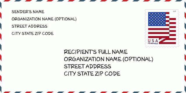
68002-5114 Boríték Példa

-
Ez egy példa az amerikai borítékra. Töltse ki a feladó adatait a bal felső sarokban, a címzett adatait pedig a jobb alsó sarokban. A szükséges információ a feladó/címzett teljes neve, utcája, városa, állam és irányítószám. A címzett információit megadtuk hivatkozásul. Általában, ha nem biztos a teljes 9 jegyű irányítószámban, akkor csak az 5 jegyű irányítószámot töltse ki a csomag elvesztésének elkerülése érdekében.
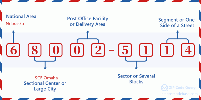
68002-5114 Alapvető jelentés
-
Mit jelent az 68002-5114 irányítószám minden számjegye? Az irányítószám két részből áll, az első öt számjegy a postahivatalig, az utolsó négy számjegy pedig egy földrajzi szegmenst azonosíthat az ötjegyű kézbesítési területen belül. A 6-7 számjegy egy szektort vagy több blokkot, a 8-9 számjegy pedig egy utcaszakaszt vagy egy oldalt jelöl.

- ·Hordozó Útvonal ID?
A 4-digit code assigned to a mail delivery or collection route within a 5-digit ZIP Code. The first character of this identification is alphabetical, and the last three are numeric: Bnnn = PO box Hnnn = Highway contract Rnnn = Rural route Cnnn = City delivery Gnnn = General delivery: R001 (Vidéki Út)
- ·Irányítószámhoz Hozzáad Alacsony Szektort?
The ZIP Add-On Low Sector and the ZIP Add-On Low Segment together form the ZIP Add-On Low Number. The ZIP Add-On Low Number is the last four positions of a ZIP+4 code; the low-end ZIP add-on in a range of codes; the add-on of the first ZIP+4 code in a consecutive series of ZIP+4 codes assigned to the delivery address. For example, most delivery addresses are assigned a single ZIP+4 code. However, large companies may be given a range of ZIP+4 codes that can be used to route mail to specific departments. A range of ZIP+4 codes can also be assigned to a corresponding range of post office boxes, and each box is mapped, one-to-one, with a ZIP+4 code in the range. A single post office box can also be assigned a range of ZIP+4 codes.: 51
- ·Irányítószámhoz Hozzáad Alacsony Szegmenst?
The ZIP Add-On Low Sector and the ZIP Add-On Low Segment together form the ZIP Add-On Low Number. The ZIP Add-On Low Number is the last four positions of a ZIP+4 code; the low-end ZIP add-on in a range of codes; the add-on of the first ZIP+4 code in a consecutive series of ZIP+4 codes assigned to the delivery address. For example, most delivery addresses are assigned a single ZIP+4 code. However, large companies may be given a range of ZIP+4 codes that can be used to route mail to specific departments. A range of ZIP+4 codes can also be assigned to a corresponding range of post office boxes, and each box is mapped, one-to-one, with a ZIP+4 code in the range. A single post office box can also be assigned a range of ZIP+4 codes.: 14
- ·Irányítószámhoz Hozzáad Magas Szektort?
The ZIP Add-On High Sector and the ZIP Add-On High Segment together form the ZIP Add-On High Number, which is the high-end ZIP add-on in a range of codes; the add-on of the last ZIP+4 code in a consecutive series of ZIP+4 codes assigned to the delivery address. Most delivery addresses are assigned a single ZIP+4 code; however, large companies may be given a range of ZIP+4 codes that can be used to route mail to specific departments. A range of ZIP+4 codes can also be assigned to a corresponding range of post office boxes, and each box is mapped, one-to-one, with a ZIP+4 code in the range. A single post office box can also be assigned a range of ZIP+4 codes. (See also ZIP Add-On Code.): 51
- ·Irányítószámhoz Hozzáad Magas Szegmenst?
The ZIP Add-On High Sector and the ZIP Add-On High Segment together form the ZIP Add-On High Number, which is the high-end ZIP add-on in a range of codes; the add-on of the last ZIP+4 code in a consecutive series of ZIP+4 codes assigned to the delivery address. Most delivery addresses are assigned a single ZIP+4 code; however, large companies may be given a range of ZIP+4 codes that can be used to route mail to specific departments. A range of ZIP+4 codes can also be assigned to a corresponding range of post office boxes, and each box is mapped, one-to-one, with a ZIP+4 code in the range. A single post office box can also be assigned a range of ZIP+4 codes. (See also ZIP Add-On Code.): 14
- ·Irányítószám Melléklet: 5114
- ·Sorozat?
The range of +4 codes. Summing the +4 Code and the +4 Range will give you the high end of the range of +4 Codes that pertain to this ZIP Code.: 0
- ·Bázis Alternatív Kód?
Code that specifies whether a record is a base (preferred) or alternate record. Base records (represented as "B") can represent a range of addresses or an individual address, such as a firm record, while alternate records (represented as "A") are individual delivery points. Government deliveries will only be listed on alternate records with the appropriate government building indicator (federal, state, or city) set.: Alap
- ·Pénzügy Száma?
A code assigned to Postal Service facilities (primarily post offices) to collect cost and statistical data and compile revenue and expense data. The state number comprises the first two positions of the finance number.: 300405
- ·Kerület Kongresszusi Szám?
A standard value identifying a geographic area within the United States served by a member of the US House of Representatives or Senate. If Army/Air Force (APO) or fleet post office (FPO), this column will be blank. If there is only one member of Congress within a state, the code will be "AL" (at large).: 01
- ·Előnyben Last Line Város Állam Kulcs?
An index to the City State file that provides the preferred last-line name for this address range.: W19465
Online Térkép

Ez az online térkép cim 19800 COUNTY ROAD 26 ARLINGTON. Lehet használni a Zoom in / out-ot. A térkép információk csak tájékoztató jellegü. A térkép információk csak tájékoztató jellegü.
Cím: 19800 (From 19800 To 19899) COUNTY ROAD 26, ARLINGTON, NE 68002-5114, USA
Hozzászólás


Új hozzászólás