Adres: 1700 (From 1700 To 1799) COUNTY ROAD B, CERESCO, NE 68017-4015, USA
Co to jest 68017-4015? 68017-4015 to kod pocztowy 5 Plus 4 liczba 1700 (From 1700 To 1799) COUNTY ROAD B, CERESCO, NE, USA. Bliższe informacje poniżej.
68017-4015 Podstawowe informacje

-
Kod Pocztowy 5 Plus 4:
68017-4015 -
Kod Pocztowy 5:
68017 -
Plus 4?40154-digits that are used to identify a geographic segment within the 5-digit delivery area, such as a city block or a group of apartments or an individual high-volume receiver of mail, or any other unit that could use an extra identifier to aid in efficient mail sorting and delivery. This code is the low end of the range of +4 Codes that pertain to this ZIP Code. ZIP+4 Codes associated with nondelivery areas are composed of valid ZIP sector numbers and "ND" for the ZIP segment number, for example 12345-12ND. Non-deliverable areas are areas to which the USPS does not deliver mail, such as vacant lots and land that borders railroad tracks. Mailers should not match an address identified as a nondelivery area. If you absolutely must have numeric characters in the Plus4Code column, you may treat "ND" values as "00" (zero zero).:
-
Kraj:
U.S. - Stany Zjednoczone -
Państwo/stan:
NE - Nebraska -
Hrabstwo:
CountyFIPS: 31155 - Saunders County -
Miasto:
CERESCO -
Ulica?COUNTY ROAD BThe official name of a street as assigned by a local governing authority. The Street Name column contains only the street name and does not include directionals (EAST, WEST, etc.) or suffixes (ST, DR, BLVD, etc.). This element may also contain literals, such as PO BOX, GENERAL DELIVERY, USS, PSC, or UNIT. Numeric street names that have numeric components that are four characters (or less) in length at are justified such that the low-order digit of the number is positioned in the fourth position of the street name column. This shift is made so that the numeric street names appear in numeric sequence.:
-
Rodzaj Danych?S: UlicaAn alphabetic value that identifies the type of data in the record. Record type codes include the following: G = General delivery H = Highrise F = Firm S = Street P = PO box R = Rural route/highway contract:
Adres

- Prymarny Niski Numer Adresu?
A house, rural route, highway contract box, or post office box number; the numeric or alphanumeric component of an address preceding the street name; the low-end address in a range of addresses. Often referred to as house number.: 1700
- Prymarny Wysoki Numer Adresu?
A house, rural route, contract box, or Post Office box number. The numeric or alphanumeric component of an address preceding the street name. The high-end address in a range of addresses. Often referred to as house number.: 1799
- Nieparzysty/Parzysty Kod Prymarny Adresu?
Code that identifies the side or sides of a street for which a given address range is applicable. For street, highrise, firm and multi-carrier records, B = Both sides of a street, E = Even side of a street (even-numbered addresses in the range); O = Odd side of a street (odd-numbered addresses in the range). For general delivery, post office box, and rural route/highway contract records, this code will always be "B" (both).: Both of Odd and Even
- Podstawowy Zakres: 1700, 1701, 1702, 1703, 1704, 1705, 1706, 1707, 1708, 1709, 1710, 1711, 1712, 1713, 1714, 1715, 1716, 1717, 1718, 1719, 1720, 1721, 1722, 1723, 1724, 1725, 1726, 1727, 1728, 1729, 1730, 1731, 1732, 1733, 1734, 1735, 1736, 1737, 1738, 1739, 1740, 1741, 1742, 1743, 1744, 1745, 1746, 1747, 1748, 1749, 1750, 1751, 1752, 1753, 1754, 1755, 1756, 1757, 1758, 1759, 1760, 1761, 1762, 1763, 1764, 1765, 1766, 1767, 1768, 1769, 1770, 1771, 1772, 1773, 1774, 1775, 1776, 1777, 1778, 1779, 1780, 1781, 1782, 1783, 1784, 1785, 1786, 1787, 1788, 1789, 1790, 1791, 1792, 1793, 1794, 1795, 1796, 1797, 1798, 1799.
Kliknij "Więcej przykładów adresów", aby wyświetlić całą listę.
1700 COUNTY ROAD B, CERESCO, NE 68017-4015
1701 COUNTY ROAD B, CERESCO, NE 68017-4015
1702 COUNTY ROAD B, CERESCO, NE 68017-4015
1703 COUNTY ROAD B, CERESCO, NE 68017-4015
1704 COUNTY ROAD B, CERESCO, NE 68017-4015
1705 COUNTY ROAD B, CERESCO, NE 68017-4015
1706 COUNTY ROAD B, CERESCO, NE 68017-4015
1707 COUNTY ROAD B, CERESCO, NE 68017-4015
1708 COUNTY ROAD B, CERESCO, NE 68017-4015
1709 COUNTY ROAD B, CERESCO, NE 68017-4015
1710 COUNTY ROAD B, CERESCO, NE 68017-4015
1711 COUNTY ROAD B, CERESCO, NE 68017-4015
1712 COUNTY ROAD B, CERESCO, NE 68017-4015
1713 COUNTY ROAD B, CERESCO, NE 68017-4015
1714 COUNTY ROAD B, CERESCO, NE 68017-4015
1715 COUNTY ROAD B, CERESCO, NE 68017-4015
1716 COUNTY ROAD B, CERESCO, NE 68017-4015
1717 COUNTY ROAD B, CERESCO, NE 68017-4015
1718 COUNTY ROAD B, CERESCO, NE 68017-4015
1719 COUNTY ROAD B, CERESCO, NE 68017-4015
1720 COUNTY ROAD B, CERESCO, NE 68017-4015
1721 COUNTY ROAD B, CERESCO, NE 68017-4015
1722 COUNTY ROAD B, CERESCO, NE 68017-4015
1723 COUNTY ROAD B, CERESCO, NE 68017-4015
1724 COUNTY ROAD B, CERESCO, NE 68017-4015
1725 COUNTY ROAD B, CERESCO, NE 68017-4015
1726 COUNTY ROAD B, CERESCO, NE 68017-4015
1727 COUNTY ROAD B, CERESCO, NE 68017-4015
1728 COUNTY ROAD B, CERESCO, NE 68017-4015
1729 COUNTY ROAD B, CERESCO, NE 68017-4015
1730 COUNTY ROAD B, CERESCO, NE 68017-4015
1731 COUNTY ROAD B, CERESCO, NE 68017-4015
1732 COUNTY ROAD B, CERESCO, NE 68017-4015
1733 COUNTY ROAD B, CERESCO, NE 68017-4015
1734 COUNTY ROAD B, CERESCO, NE 68017-4015
1735 COUNTY ROAD B, CERESCO, NE 68017-4015
1736 COUNTY ROAD B, CERESCO, NE 68017-4015
1737 COUNTY ROAD B, CERESCO, NE 68017-4015
1738 COUNTY ROAD B, CERESCO, NE 68017-4015
1739 COUNTY ROAD B, CERESCO, NE 68017-4015
1740 COUNTY ROAD B, CERESCO, NE 68017-4015
1741 COUNTY ROAD B, CERESCO, NE 68017-4015
1742 COUNTY ROAD B, CERESCO, NE 68017-4015
1743 COUNTY ROAD B, CERESCO, NE 68017-4015
1744 COUNTY ROAD B, CERESCO, NE 68017-4015
1745 COUNTY ROAD B, CERESCO, NE 68017-4015
1746 COUNTY ROAD B, CERESCO, NE 68017-4015
1747 COUNTY ROAD B, CERESCO, NE 68017-4015
1748 COUNTY ROAD B, CERESCO, NE 68017-4015
1749 COUNTY ROAD B, CERESCO, NE 68017-4015
1750 COUNTY ROAD B, CERESCO, NE 68017-4015
1751 COUNTY ROAD B, CERESCO, NE 68017-4015
1752 COUNTY ROAD B, CERESCO, NE 68017-4015
1753 COUNTY ROAD B, CERESCO, NE 68017-4015
1754 COUNTY ROAD B, CERESCO, NE 68017-4015
1755 COUNTY ROAD B, CERESCO, NE 68017-4015
1756 COUNTY ROAD B, CERESCO, NE 68017-4015
1757 COUNTY ROAD B, CERESCO, NE 68017-4015
1758 COUNTY ROAD B, CERESCO, NE 68017-4015
1759 COUNTY ROAD B, CERESCO, NE 68017-4015
1760 COUNTY ROAD B, CERESCO, NE 68017-4015
1761 COUNTY ROAD B, CERESCO, NE 68017-4015
1762 COUNTY ROAD B, CERESCO, NE 68017-4015
1763 COUNTY ROAD B, CERESCO, NE 68017-4015
1764 COUNTY ROAD B, CERESCO, NE 68017-4015
1765 COUNTY ROAD B, CERESCO, NE 68017-4015
1766 COUNTY ROAD B, CERESCO, NE 68017-4015
1767 COUNTY ROAD B, CERESCO, NE 68017-4015
1768 COUNTY ROAD B, CERESCO, NE 68017-4015
1769 COUNTY ROAD B, CERESCO, NE 68017-4015
1770 COUNTY ROAD B, CERESCO, NE 68017-4015
1771 COUNTY ROAD B, CERESCO, NE 68017-4015
1772 COUNTY ROAD B, CERESCO, NE 68017-4015
1773 COUNTY ROAD B, CERESCO, NE 68017-4015
1774 COUNTY ROAD B, CERESCO, NE 68017-4015
1775 COUNTY ROAD B, CERESCO, NE 68017-4015
1776 COUNTY ROAD B, CERESCO, NE 68017-4015
1777 COUNTY ROAD B, CERESCO, NE 68017-4015
1778 COUNTY ROAD B, CERESCO, NE 68017-4015
1779 COUNTY ROAD B, CERESCO, NE 68017-4015
1780 COUNTY ROAD B, CERESCO, NE 68017-4015
1781 COUNTY ROAD B, CERESCO, NE 68017-4015
1782 COUNTY ROAD B, CERESCO, NE 68017-4015
1783 COUNTY ROAD B, CERESCO, NE 68017-4015
1784 COUNTY ROAD B, CERESCO, NE 68017-4015
1785 COUNTY ROAD B, CERESCO, NE 68017-4015
1786 COUNTY ROAD B, CERESCO, NE 68017-4015
1787 COUNTY ROAD B, CERESCO, NE 68017-4015
1788 COUNTY ROAD B, CERESCO, NE 68017-4015
1789 COUNTY ROAD B, CERESCO, NE 68017-4015
1790 COUNTY ROAD B, CERESCO, NE 68017-4015
1791 COUNTY ROAD B, CERESCO, NE 68017-4015
1792 COUNTY ROAD B, CERESCO, NE 68017-4015
1793 COUNTY ROAD B, CERESCO, NE 68017-4015
1794 COUNTY ROAD B, CERESCO, NE 68017-4015
1795 COUNTY ROAD B, CERESCO, NE 68017-4015
1796 COUNTY ROAD B, CERESCO, NE 68017-4015
1797 COUNTY ROAD B, CERESCO, NE 68017-4015
1798 COUNTY ROAD B, CERESCO, NE 68017-4015
1799 COUNTY ROAD B, CERESCO, NE 68017-4015
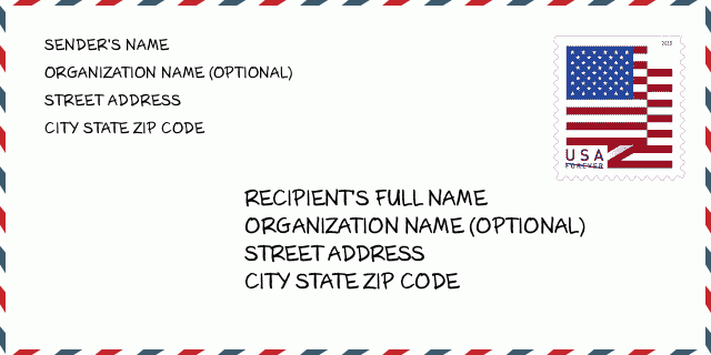
Adres Przykład
CERESCO NE 68017-4015
UNITED STATES OF AMERICA
68017-4015 Przykład Koperty

-
To jest przykład koperty amerykańskiej. Wpisz informacje o nadawcy w lewym górnym rogu i informacje o odbiorcy w prawym dolnym rogu. Niezbędne informacje to imię i nazwisko nadawcy/odbiorcy, adres, miasto, województwo i kod pocztowy. Dane adresowe odbiorcy zostały podane w celach informacyjnych. Ogólnie rzecz biorąc, jeśli nie masz pewności co do pełnego 9-cyfrowego kodu pocztowego, możesz wpisać tylko 5-cyfrowy kod pocztowy, aby uniknąć utraty paczki.
68017-4015 Podstawowe znaczenie
-
Co oznacza każda cyfra kodu pocztowego 68017-4015? Kod pocztowy + 4 składa się z dwóch części, pierwsze pięć cyfr może znajdować się w urzędzie pocztowym, a ostatnie cztery cyfry mogą identyfikować segment geograficzny w pięciocyfrowym obszarze dostawy. Cyfry 6-7 oznaczają sektor lub kilka bloków, a cyfry 8-9 oznaczają odcinek lub jedną stronę ulicy.
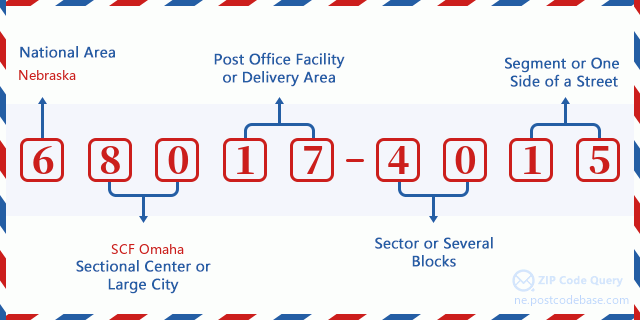

- ·ID Trasy Dostawy?
A 4-digit code assigned to a mail delivery or collection route within a 5-digit ZIP Code. The first character of this identification is alphabetical, and the last three are numeric: Bnnn = PO box Hnnn = Highway contract Rnnn = Rural route Cnnn = City delivery Gnnn = General delivery: R001 (Droga Wiejska)
- ·Sektor Niski ZIP Dodatku?
The ZIP Add-On Low Sector and the ZIP Add-On Low Segment together form the ZIP Add-On Low Number. The ZIP Add-On Low Number is the last four positions of a ZIP+4 code; the low-end ZIP add-on in a range of codes; the add-on of the first ZIP+4 code in a consecutive series of ZIP+4 codes assigned to the delivery address. For example, most delivery addresses are assigned a single ZIP+4 code. However, large companies may be given a range of ZIP+4 codes that can be used to route mail to specific departments. A range of ZIP+4 codes can also be assigned to a corresponding range of post office boxes, and each box is mapped, one-to-one, with a ZIP+4 code in the range. A single post office box can also be assigned a range of ZIP+4 codes.: 40
- ·Segment Niski ZIP Dodatku?
The ZIP Add-On Low Sector and the ZIP Add-On Low Segment together form the ZIP Add-On Low Number. The ZIP Add-On Low Number is the last four positions of a ZIP+4 code; the low-end ZIP add-on in a range of codes; the add-on of the first ZIP+4 code in a consecutive series of ZIP+4 codes assigned to the delivery address. For example, most delivery addresses are assigned a single ZIP+4 code. However, large companies may be given a range of ZIP+4 codes that can be used to route mail to specific departments. A range of ZIP+4 codes can also be assigned to a corresponding range of post office boxes, and each box is mapped, one-to-one, with a ZIP+4 code in the range. A single post office box can also be assigned a range of ZIP+4 codes.: 15
- ·Sektor Wysoki ZIP Dodatku?
The ZIP Add-On High Sector and the ZIP Add-On High Segment together form the ZIP Add-On High Number, which is the high-end ZIP add-on in a range of codes; the add-on of the last ZIP+4 code in a consecutive series of ZIP+4 codes assigned to the delivery address. Most delivery addresses are assigned a single ZIP+4 code; however, large companies may be given a range of ZIP+4 codes that can be used to route mail to specific departments. A range of ZIP+4 codes can also be assigned to a corresponding range of post office boxes, and each box is mapped, one-to-one, with a ZIP+4 code in the range. A single post office box can also be assigned a range of ZIP+4 codes. (See also ZIP Add-On Code.): 40
- ·Segment Wysoki ZIP Dodatku?
The ZIP Add-On High Sector and the ZIP Add-On High Segment together form the ZIP Add-On High Number, which is the high-end ZIP add-on in a range of codes; the add-on of the last ZIP+4 code in a consecutive series of ZIP+4 codes assigned to the delivery address. Most delivery addresses are assigned a single ZIP+4 code; however, large companies may be given a range of ZIP+4 codes that can be used to route mail to specific departments. A range of ZIP+4 codes can also be assigned to a corresponding range of post office boxes, and each box is mapped, one-to-one, with a ZIP+4 code in the range. A single post office box can also be assigned a range of ZIP+4 codes. (See also ZIP Add-On Code.): 15
- ·PNA Dodatek: 4015
- ·Zakres?
The range of +4 codes. Summing the +4 Code and the +4 Range will give you the high end of the range of +4 Codes that pertain to this ZIP Code.: 0
- ·Kod Alternatywny Bazy?
Code that specifies whether a record is a base (preferred) or alternate record. Base records (represented as "B") can represent a range of addresses or an individual address, such as a firm record, while alternate records (represented as "A") are individual delivery points. Government deliveries will only be listed on alternate records with the appropriate government building indicator (federal, state, or city) set.: Baza
- ·Numer Finansowy?
A code assigned to Postal Service facilities (primarily post offices) to collect cost and statistical data and compile revenue and expense data. The state number comprises the first two positions of the finance number.: 301740
- ·Numer Dystryktu Kongresowego?
A standard value identifying a geographic area within the United States served by a member of the US House of Representatives or Senate. If Army/Air Force (APO) or fleet post office (FPO), this column will be blank. If there is only one member of Congress within a state, the code will be "AL" (at large).: 01
- ·Preferowany Klucz Miasta Stanu Ostatniej Linii?
An index to the City State file that provides the preferred last-line name for this address range.: W19596
Mapa

To mapa sieciowa adresu 1700 COUNTY ROAD B CERESCO. Mapę można przybliżyć. Mapa przeznaczona jest wyłącznie dla celów informacyjnych.
Adres: 1700 (From 1700 To 1799) COUNTY ROAD B, CERESCO, NE 68017-4015, USA
Komentarz


Dodaj komentarz