Adres: 600 (From 600 To 699) COUNTY ROAD 17, CERESCO, NE 68017-4040, USA
Co to jest 68017-4040? 68017-4040 to kod pocztowy 5 Plus 4 liczba 600 (From 600 To 699) COUNTY ROAD 17, CERESCO, NE, USA. Bliższe informacje poniżej.
68017-4040 Podstawowe informacje

-
Kod Pocztowy 5 Plus 4:
68017-4040 -
Kod Pocztowy 5:
68017 -
Plus 4?40404-digits that are used to identify a geographic segment within the 5-digit delivery area, such as a city block or a group of apartments or an individual high-volume receiver of mail, or any other unit that could use an extra identifier to aid in efficient mail sorting and delivery. This code is the low end of the range of +4 Codes that pertain to this ZIP Code. ZIP+4 Codes associated with nondelivery areas are composed of valid ZIP sector numbers and "ND" for the ZIP segment number, for example 12345-12ND. Non-deliverable areas are areas to which the USPS does not deliver mail, such as vacant lots and land that borders railroad tracks. Mailers should not match an address identified as a nondelivery area. If you absolutely must have numeric characters in the Plus4Code column, you may treat "ND" values as "00" (zero zero).:
-
Kraj:
U.S. - Stany Zjednoczone -
Państwo/stan:
NE - Nebraska -
Hrabstwo:
CountyFIPS: 31155 - Saunders County -
Miasto:
CERESCO -
Ulica?COUNTY ROAD 17The official name of a street as assigned by a local governing authority. The Street Name column contains only the street name and does not include directionals (EAST, WEST, etc.) or suffixes (ST, DR, BLVD, etc.). This element may also contain literals, such as PO BOX, GENERAL DELIVERY, USS, PSC, or UNIT. Numeric street names that have numeric components that are four characters (or less) in length at are justified such that the low-order digit of the number is positioned in the fourth position of the street name column. This shift is made so that the numeric street names appear in numeric sequence.:
-
Rodzaj Danych?S: UlicaAn alphabetic value that identifies the type of data in the record. Record type codes include the following: G = General delivery H = Highrise F = Firm S = Street P = PO box R = Rural route/highway contract:
Adres

- Prymarny Niski Numer Adresu?
A house, rural route, highway contract box, or post office box number; the numeric or alphanumeric component of an address preceding the street name; the low-end address in a range of addresses. Often referred to as house number.: 600
- Prymarny Wysoki Numer Adresu?
A house, rural route, contract box, or Post Office box number. The numeric or alphanumeric component of an address preceding the street name. The high-end address in a range of addresses. Often referred to as house number.: 699
- Nieparzysty/Parzysty Kod Prymarny Adresu?
Code that identifies the side or sides of a street for which a given address range is applicable. For street, highrise, firm and multi-carrier records, B = Both sides of a street, E = Even side of a street (even-numbered addresses in the range); O = Odd side of a street (odd-numbered addresses in the range). For general delivery, post office box, and rural route/highway contract records, this code will always be "B" (both).: Both of Odd and Even
- Podstawowy Zakres: 600, 601, 602, 603, 604, 605, 606, 607, 608, 609, 610, 611, 612, 613, 614, 615, 616, 617, 618, 619, 620, 621, 622, 623, 624, 625, 626, 627, 628, 629, 630, 631, 632, 633, 634, 635, 636, 637, 638, 639, 640, 641, 642, 643, 644, 645, 646, 647, 648, 649, 650, 651, 652, 653, 654, 655, 656, 657, 658, 659, 660, 661, 662, 663, 664, 665, 666, 667, 668, 669, 670, 671, 672, 673, 674, 675, 676, 677, 678, 679, 680, 681, 682, 683, 684, 685, 686, 687, 688, 689, 690, 691, 692, 693, 694, 695, 696, 697, 698, 699.
Kliknij "Więcej przykładów adresów", aby wyświetlić całą listę.
600 COUNTY ROAD 17, CERESCO, NE 68017-4040
601 COUNTY ROAD 17, CERESCO, NE 68017-4040
602 COUNTY ROAD 17, CERESCO, NE 68017-4040
603 COUNTY ROAD 17, CERESCO, NE 68017-4040
604 COUNTY ROAD 17, CERESCO, NE 68017-4040
605 COUNTY ROAD 17, CERESCO, NE 68017-4040
606 COUNTY ROAD 17, CERESCO, NE 68017-4040
607 COUNTY ROAD 17, CERESCO, NE 68017-4040
608 COUNTY ROAD 17, CERESCO, NE 68017-4040
609 COUNTY ROAD 17, CERESCO, NE 68017-4040
610 COUNTY ROAD 17, CERESCO, NE 68017-4040
611 COUNTY ROAD 17, CERESCO, NE 68017-4040
612 COUNTY ROAD 17, CERESCO, NE 68017-4040
613 COUNTY ROAD 17, CERESCO, NE 68017-4040
614 COUNTY ROAD 17, CERESCO, NE 68017-4040
615 COUNTY ROAD 17, CERESCO, NE 68017-4040
616 COUNTY ROAD 17, CERESCO, NE 68017-4040
617 COUNTY ROAD 17, CERESCO, NE 68017-4040
618 COUNTY ROAD 17, CERESCO, NE 68017-4040
619 COUNTY ROAD 17, CERESCO, NE 68017-4040
620 COUNTY ROAD 17, CERESCO, NE 68017-4040
621 COUNTY ROAD 17, CERESCO, NE 68017-4040
622 COUNTY ROAD 17, CERESCO, NE 68017-4040
623 COUNTY ROAD 17, CERESCO, NE 68017-4040
624 COUNTY ROAD 17, CERESCO, NE 68017-4040
625 COUNTY ROAD 17, CERESCO, NE 68017-4040
626 COUNTY ROAD 17, CERESCO, NE 68017-4040
627 COUNTY ROAD 17, CERESCO, NE 68017-4040
628 COUNTY ROAD 17, CERESCO, NE 68017-4040
629 COUNTY ROAD 17, CERESCO, NE 68017-4040
630 COUNTY ROAD 17, CERESCO, NE 68017-4040
631 COUNTY ROAD 17, CERESCO, NE 68017-4040
632 COUNTY ROAD 17, CERESCO, NE 68017-4040
633 COUNTY ROAD 17, CERESCO, NE 68017-4040
634 COUNTY ROAD 17, CERESCO, NE 68017-4040
635 COUNTY ROAD 17, CERESCO, NE 68017-4040
636 COUNTY ROAD 17, CERESCO, NE 68017-4040
637 COUNTY ROAD 17, CERESCO, NE 68017-4040
638 COUNTY ROAD 17, CERESCO, NE 68017-4040
639 COUNTY ROAD 17, CERESCO, NE 68017-4040
640 COUNTY ROAD 17, CERESCO, NE 68017-4040
641 COUNTY ROAD 17, CERESCO, NE 68017-4040
642 COUNTY ROAD 17, CERESCO, NE 68017-4040
643 COUNTY ROAD 17, CERESCO, NE 68017-4040
644 COUNTY ROAD 17, CERESCO, NE 68017-4040
645 COUNTY ROAD 17, CERESCO, NE 68017-4040
646 COUNTY ROAD 17, CERESCO, NE 68017-4040
647 COUNTY ROAD 17, CERESCO, NE 68017-4040
648 COUNTY ROAD 17, CERESCO, NE 68017-4040
649 COUNTY ROAD 17, CERESCO, NE 68017-4040
650 COUNTY ROAD 17, CERESCO, NE 68017-4040
651 COUNTY ROAD 17, CERESCO, NE 68017-4040
652 COUNTY ROAD 17, CERESCO, NE 68017-4040
653 COUNTY ROAD 17, CERESCO, NE 68017-4040
654 COUNTY ROAD 17, CERESCO, NE 68017-4040
655 COUNTY ROAD 17, CERESCO, NE 68017-4040
656 COUNTY ROAD 17, CERESCO, NE 68017-4040
657 COUNTY ROAD 17, CERESCO, NE 68017-4040
658 COUNTY ROAD 17, CERESCO, NE 68017-4040
659 COUNTY ROAD 17, CERESCO, NE 68017-4040
660 COUNTY ROAD 17, CERESCO, NE 68017-4040
661 COUNTY ROAD 17, CERESCO, NE 68017-4040
662 COUNTY ROAD 17, CERESCO, NE 68017-4040
663 COUNTY ROAD 17, CERESCO, NE 68017-4040
664 COUNTY ROAD 17, CERESCO, NE 68017-4040
665 COUNTY ROAD 17, CERESCO, NE 68017-4040
666 COUNTY ROAD 17, CERESCO, NE 68017-4040
667 COUNTY ROAD 17, CERESCO, NE 68017-4040
668 COUNTY ROAD 17, CERESCO, NE 68017-4040
669 COUNTY ROAD 17, CERESCO, NE 68017-4040
670 COUNTY ROAD 17, CERESCO, NE 68017-4040
671 COUNTY ROAD 17, CERESCO, NE 68017-4040
672 COUNTY ROAD 17, CERESCO, NE 68017-4040
673 COUNTY ROAD 17, CERESCO, NE 68017-4040
674 COUNTY ROAD 17, CERESCO, NE 68017-4040
675 COUNTY ROAD 17, CERESCO, NE 68017-4040
676 COUNTY ROAD 17, CERESCO, NE 68017-4040
677 COUNTY ROAD 17, CERESCO, NE 68017-4040
678 COUNTY ROAD 17, CERESCO, NE 68017-4040
679 COUNTY ROAD 17, CERESCO, NE 68017-4040
680 COUNTY ROAD 17, CERESCO, NE 68017-4040
681 COUNTY ROAD 17, CERESCO, NE 68017-4040
682 COUNTY ROAD 17, CERESCO, NE 68017-4040
683 COUNTY ROAD 17, CERESCO, NE 68017-4040
684 COUNTY ROAD 17, CERESCO, NE 68017-4040
685 COUNTY ROAD 17, CERESCO, NE 68017-4040
686 COUNTY ROAD 17, CERESCO, NE 68017-4040
687 COUNTY ROAD 17, CERESCO, NE 68017-4040
688 COUNTY ROAD 17, CERESCO, NE 68017-4040
689 COUNTY ROAD 17, CERESCO, NE 68017-4040
690 COUNTY ROAD 17, CERESCO, NE 68017-4040
691 COUNTY ROAD 17, CERESCO, NE 68017-4040
692 COUNTY ROAD 17, CERESCO, NE 68017-4040
693 COUNTY ROAD 17, CERESCO, NE 68017-4040
694 COUNTY ROAD 17, CERESCO, NE 68017-4040
695 COUNTY ROAD 17, CERESCO, NE 68017-4040
696 COUNTY ROAD 17, CERESCO, NE 68017-4040
697 COUNTY ROAD 17, CERESCO, NE 68017-4040
698 COUNTY ROAD 17, CERESCO, NE 68017-4040
699 COUNTY ROAD 17, CERESCO, NE 68017-4040
Adres Przykład
CERESCO NE 68017-4040
UNITED STATES OF AMERICA
68017-4040 Przykład Koperty

-
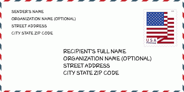
To jest przykład koperty amerykańskiej. Wpisz informacje o nadawcy w lewym górnym rogu i informacje o odbiorcy w prawym dolnym rogu. Niezbędne informacje to imię i nazwisko nadawcy/odbiorcy, adres, miasto, województwo i kod pocztowy. Dane adresowe odbiorcy zostały podane w celach informacyjnych. Ogólnie rzecz biorąc, jeśli nie masz pewności co do pełnego 9-cyfrowego kodu pocztowego, możesz wpisać tylko 5-cyfrowy kod pocztowy, aby uniknąć utraty paczki.
68017-4040 Podstawowe znaczenie
-
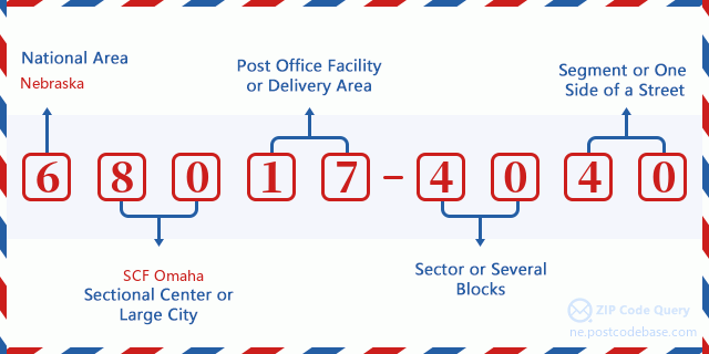
Co oznacza każda cyfra kodu pocztowego 68017-4040? Kod pocztowy + 4 składa się z dwóch części, pierwsze pięć cyfr może znajdować się w urzędzie pocztowym, a ostatnie cztery cyfry mogą identyfikować segment geograficzny w pięciocyfrowym obszarze dostawy. Cyfry 6-7 oznaczają sektor lub kilka bloków, a cyfry 8-9 oznaczają odcinek lub jedną stronę ulicy.

- ·ID Trasy Dostawy?
A 4-digit code assigned to a mail delivery or collection route within a 5-digit ZIP Code. The first character of this identification is alphabetical, and the last three are numeric: Bnnn = PO box Hnnn = Highway contract Rnnn = Rural route Cnnn = City delivery Gnnn = General delivery: R001 (Droga Wiejska)
- ·Sektor Niski ZIP Dodatku?
The ZIP Add-On Low Sector and the ZIP Add-On Low Segment together form the ZIP Add-On Low Number. The ZIP Add-On Low Number is the last four positions of a ZIP+4 code; the low-end ZIP add-on in a range of codes; the add-on of the first ZIP+4 code in a consecutive series of ZIP+4 codes assigned to the delivery address. For example, most delivery addresses are assigned a single ZIP+4 code. However, large companies may be given a range of ZIP+4 codes that can be used to route mail to specific departments. A range of ZIP+4 codes can also be assigned to a corresponding range of post office boxes, and each box is mapped, one-to-one, with a ZIP+4 code in the range. A single post office box can also be assigned a range of ZIP+4 codes.: 40
- ·Segment Niski ZIP Dodatku?
The ZIP Add-On Low Sector and the ZIP Add-On Low Segment together form the ZIP Add-On Low Number. The ZIP Add-On Low Number is the last four positions of a ZIP+4 code; the low-end ZIP add-on in a range of codes; the add-on of the first ZIP+4 code in a consecutive series of ZIP+4 codes assigned to the delivery address. For example, most delivery addresses are assigned a single ZIP+4 code. However, large companies may be given a range of ZIP+4 codes that can be used to route mail to specific departments. A range of ZIP+4 codes can also be assigned to a corresponding range of post office boxes, and each box is mapped, one-to-one, with a ZIP+4 code in the range. A single post office box can also be assigned a range of ZIP+4 codes.: 40
- ·Sektor Wysoki ZIP Dodatku?
The ZIP Add-On High Sector and the ZIP Add-On High Segment together form the ZIP Add-On High Number, which is the high-end ZIP add-on in a range of codes; the add-on of the last ZIP+4 code in a consecutive series of ZIP+4 codes assigned to the delivery address. Most delivery addresses are assigned a single ZIP+4 code; however, large companies may be given a range of ZIP+4 codes that can be used to route mail to specific departments. A range of ZIP+4 codes can also be assigned to a corresponding range of post office boxes, and each box is mapped, one-to-one, with a ZIP+4 code in the range. A single post office box can also be assigned a range of ZIP+4 codes. (See also ZIP Add-On Code.): 40
- ·Segment Wysoki ZIP Dodatku?
The ZIP Add-On High Sector and the ZIP Add-On High Segment together form the ZIP Add-On High Number, which is the high-end ZIP add-on in a range of codes; the add-on of the last ZIP+4 code in a consecutive series of ZIP+4 codes assigned to the delivery address. Most delivery addresses are assigned a single ZIP+4 code; however, large companies may be given a range of ZIP+4 codes that can be used to route mail to specific departments. A range of ZIP+4 codes can also be assigned to a corresponding range of post office boxes, and each box is mapped, one-to-one, with a ZIP+4 code in the range. A single post office box can also be assigned a range of ZIP+4 codes. (See also ZIP Add-On Code.): 40
- ·PNA Dodatek: 4040
- ·Zakres?
The range of +4 codes. Summing the +4 Code and the +4 Range will give you the high end of the range of +4 Codes that pertain to this ZIP Code.: 0
- ·Kod Alternatywny Bazy?
Code that specifies whether a record is a base (preferred) or alternate record. Base records (represented as "B") can represent a range of addresses or an individual address, such as a firm record, while alternate records (represented as "A") are individual delivery points. Government deliveries will only be listed on alternate records with the appropriate government building indicator (federal, state, or city) set.: Baza
- ·Numer Finansowy?
A code assigned to Postal Service facilities (primarily post offices) to collect cost and statistical data and compile revenue and expense data. The state number comprises the first two positions of the finance number.: 301740
- ·Numer Dystryktu Kongresowego?
A standard value identifying a geographic area within the United States served by a member of the US House of Representatives or Senate. If Army/Air Force (APO) or fleet post office (FPO), this column will be blank. If there is only one member of Congress within a state, the code will be "AL" (at large).: 01
- ·Preferowany Klucz Miasta Stanu Ostatniej Linii?
An index to the City State file that provides the preferred last-line name for this address range.: W19596
Mapa

To mapa sieciowa adresu 600 COUNTY ROAD 17 CERESCO. Mapę można przybliżyć. Mapa przeznaczona jest wyłącznie dla celów informacyjnych.
Adres: 600 (From 600 To 699) COUNTY ROAD 17, CERESCO, NE 68017-4040, USA
Komentarz


Dodaj komentarz