ที่อยู่: 18500 (From 18500 To 18599) COUNTY ROAD P31, BLAIR, NE 68008-5545, USA
68008-5545คืออะไร 68008-5545 เป็นรหัสไปรษณีย์ห้าบวกสี่หลัก 18500 (From 18500 To 18599) COUNTY ROAD P31, BLAIR, NE, USA มีรายละเอียดดังต่อไปนี้
68008-5545 ข้อมูลพื้นฐาน

-
รหัสไปรษณีย์ 5 พลัส 4:
68008-5545 -
รหัสไปรษณีย์ 5:
68008 -
พลัส 4?55454-digits that are used to identify a geographic segment within the 5-digit delivery area, such as a city block or a group of apartments or an individual high-volume receiver of mail, or any other unit that could use an extra identifier to aid in efficient mail sorting and delivery. This code is the low end of the range of +4 Codes that pertain to this ZIP Code. ZIP+4 Codes associated with nondelivery areas are composed of valid ZIP sector numbers and "ND" for the ZIP segment number, for example 12345-12ND. Non-deliverable areas are areas to which the USPS does not deliver mail, such as vacant lots and land that borders railroad tracks. Mailers should not match an address identified as a nondelivery area. If you absolutely must have numeric characters in the Plus4Code column, you may treat "ND" values as "00" (zero zero).:
-
ประเทศ:
U.S. - ประเทศสหรัฐอเมริกา -
รัฐ:
NE - เนบราสกา -
อำเภอ:
CountyFIPS: 31177 - Washington County -
เมือง:
BLAIR -
ถนน?COUNTY ROAD P31The official name of a street as assigned by a local governing authority. The Street Name column contains only the street name and does not include directionals (EAST, WEST, etc.) or suffixes (ST, DR, BLVD, etc.). This element may also contain literals, such as PO BOX, GENERAL DELIVERY, USS, PSC, or UNIT. Numeric street names that have numeric components that are four characters (or less) in length at are justified such that the low-order digit of the number is positioned in the fourth position of the street name column. This shift is made so that the numeric street names appear in numeric sequence.:
-
ประเภทระเบียน?S: ถนนAn alphabetic value that identifies the type of data in the record. Record type codes include the following: G = General delivery H = Highrise F = Firm S = Street P = PO box R = Rural route/highway contract:
ที่อยู่

- ตัวเลขหลักต่ำของที่อยู่หลัก?
A house, rural route, highway contract box, or post office box number; the numeric or alphanumeric component of an address preceding the street name; the low-end address in a range of addresses. Often referred to as house number.: 18500
- ตัวเลขหลักสูงของที่อยู่หลัก?
A house, rural route, contract box, or Post Office box number. The numeric or alphanumeric component of an address preceding the street name. The high-end address in a range of addresses. Often referred to as house number.: 18599
- เลขคี่ / เลขคู่ที่อยู่หลัก?
Code that identifies the side or sides of a street for which a given address range is applicable. For street, highrise, firm and multi-carrier records, B = Both sides of a street, E = Even side of a street (even-numbered addresses in the range); O = Odd side of a street (odd-numbered addresses in the range). For general delivery, post office box, and rural route/highway contract records, this code will always be "B" (both).: Both of Odd and Even
- หลัก เทือกเขา: 18500, 18501, 18502, 18503, 18504, 18505, 18506, 18507, 18508, 18509, 18510, 18511, 18512, 18513, 18514, 18515, 18516, 18517, 18518, 18519, 18520, 18521, 18522, 18523, 18524, 18525, 18526, 18527, 18528, 18529, 18530, 18531, 18532, 18533, 18534, 18535, 18536, 18537, 18538, 18539, 18540, 18541, 18542, 18543, 18544, 18545, 18546, 18547, 18548, 18549, 18550, 18551, 18552, 18553, 18554, 18555, 18556, 18557, 18558, 18559, 18560, 18561, 18562, 18563, 18564, 18565, 18566, 18567, 18568, 18569, 18570, 18571, 18572, 18573, 18574, 18575, 18576, 18577, 18578, 18579, 18580, 18581, 18582, 18583, 18584, 18585, 18586, 18587, 18588, 18589, 18590, 18591, 18592, 18593, 18594, 18595, 18596, 18597, 18598, 18599.
โปรดคลิก "ตัวอย่างที่อยู่เพิ่มเติม" เพื่อดูรายการทั้งหมด
18500 COUNTY ROAD P31, BLAIR, NE 68008-5545
18501 COUNTY ROAD P31, BLAIR, NE 68008-5545
18502 COUNTY ROAD P31, BLAIR, NE 68008-5545
18503 COUNTY ROAD P31, BLAIR, NE 68008-5545
18504 COUNTY ROAD P31, BLAIR, NE 68008-5545
18505 COUNTY ROAD P31, BLAIR, NE 68008-5545
18506 COUNTY ROAD P31, BLAIR, NE 68008-5545
18507 COUNTY ROAD P31, BLAIR, NE 68008-5545
18508 COUNTY ROAD P31, BLAIR, NE 68008-5545
18509 COUNTY ROAD P31, BLAIR, NE 68008-5545
18510 COUNTY ROAD P31, BLAIR, NE 68008-5545
18511 COUNTY ROAD P31, BLAIR, NE 68008-5545
18512 COUNTY ROAD P31, BLAIR, NE 68008-5545
18513 COUNTY ROAD P31, BLAIR, NE 68008-5545
18514 COUNTY ROAD P31, BLAIR, NE 68008-5545
18515 COUNTY ROAD P31, BLAIR, NE 68008-5545
18516 COUNTY ROAD P31, BLAIR, NE 68008-5545
18517 COUNTY ROAD P31, BLAIR, NE 68008-5545
18518 COUNTY ROAD P31, BLAIR, NE 68008-5545
18519 COUNTY ROAD P31, BLAIR, NE 68008-5545
18520 COUNTY ROAD P31, BLAIR, NE 68008-5545
18521 COUNTY ROAD P31, BLAIR, NE 68008-5545
18522 COUNTY ROAD P31, BLAIR, NE 68008-5545
18523 COUNTY ROAD P31, BLAIR, NE 68008-5545
18524 COUNTY ROAD P31, BLAIR, NE 68008-5545
18525 COUNTY ROAD P31, BLAIR, NE 68008-5545
18526 COUNTY ROAD P31, BLAIR, NE 68008-5545
18527 COUNTY ROAD P31, BLAIR, NE 68008-5545
18528 COUNTY ROAD P31, BLAIR, NE 68008-5545
18529 COUNTY ROAD P31, BLAIR, NE 68008-5545
18530 COUNTY ROAD P31, BLAIR, NE 68008-5545
18531 COUNTY ROAD P31, BLAIR, NE 68008-5545
18532 COUNTY ROAD P31, BLAIR, NE 68008-5545
18533 COUNTY ROAD P31, BLAIR, NE 68008-5545
18534 COUNTY ROAD P31, BLAIR, NE 68008-5545
18535 COUNTY ROAD P31, BLAIR, NE 68008-5545
18536 COUNTY ROAD P31, BLAIR, NE 68008-5545
18537 COUNTY ROAD P31, BLAIR, NE 68008-5545
18538 COUNTY ROAD P31, BLAIR, NE 68008-5545
18539 COUNTY ROAD P31, BLAIR, NE 68008-5545
18540 COUNTY ROAD P31, BLAIR, NE 68008-5545
18541 COUNTY ROAD P31, BLAIR, NE 68008-5545
18542 COUNTY ROAD P31, BLAIR, NE 68008-5545
18543 COUNTY ROAD P31, BLAIR, NE 68008-5545
18544 COUNTY ROAD P31, BLAIR, NE 68008-5545
18545 COUNTY ROAD P31, BLAIR, NE 68008-5545
18546 COUNTY ROAD P31, BLAIR, NE 68008-5545
18547 COUNTY ROAD P31, BLAIR, NE 68008-5545
18548 COUNTY ROAD P31, BLAIR, NE 68008-5545
18549 COUNTY ROAD P31, BLAIR, NE 68008-5545
18550 COUNTY ROAD P31, BLAIR, NE 68008-5545
18551 COUNTY ROAD P31, BLAIR, NE 68008-5545
18552 COUNTY ROAD P31, BLAIR, NE 68008-5545
18553 COUNTY ROAD P31, BLAIR, NE 68008-5545
18554 COUNTY ROAD P31, BLAIR, NE 68008-5545
18555 COUNTY ROAD P31, BLAIR, NE 68008-5545
18556 COUNTY ROAD P31, BLAIR, NE 68008-5545
18557 COUNTY ROAD P31, BLAIR, NE 68008-5545
18558 COUNTY ROAD P31, BLAIR, NE 68008-5545
18559 COUNTY ROAD P31, BLAIR, NE 68008-5545
18560 COUNTY ROAD P31, BLAIR, NE 68008-5545
18561 COUNTY ROAD P31, BLAIR, NE 68008-5545
18562 COUNTY ROAD P31, BLAIR, NE 68008-5545
18563 COUNTY ROAD P31, BLAIR, NE 68008-5545
18564 COUNTY ROAD P31, BLAIR, NE 68008-5545
18565 COUNTY ROAD P31, BLAIR, NE 68008-5545
18566 COUNTY ROAD P31, BLAIR, NE 68008-5545
18567 COUNTY ROAD P31, BLAIR, NE 68008-5545
18568 COUNTY ROAD P31, BLAIR, NE 68008-5545
18569 COUNTY ROAD P31, BLAIR, NE 68008-5545
18570 COUNTY ROAD P31, BLAIR, NE 68008-5545
18571 COUNTY ROAD P31, BLAIR, NE 68008-5545
18572 COUNTY ROAD P31, BLAIR, NE 68008-5545
18573 COUNTY ROAD P31, BLAIR, NE 68008-5545
18574 COUNTY ROAD P31, BLAIR, NE 68008-5545
18575 COUNTY ROAD P31, BLAIR, NE 68008-5545
18576 COUNTY ROAD P31, BLAIR, NE 68008-5545
18577 COUNTY ROAD P31, BLAIR, NE 68008-5545
18578 COUNTY ROAD P31, BLAIR, NE 68008-5545
18579 COUNTY ROAD P31, BLAIR, NE 68008-5545
18580 COUNTY ROAD P31, BLAIR, NE 68008-5545
18581 COUNTY ROAD P31, BLAIR, NE 68008-5545
18582 COUNTY ROAD P31, BLAIR, NE 68008-5545
18583 COUNTY ROAD P31, BLAIR, NE 68008-5545
18584 COUNTY ROAD P31, BLAIR, NE 68008-5545
18585 COUNTY ROAD P31, BLAIR, NE 68008-5545
18586 COUNTY ROAD P31, BLAIR, NE 68008-5545
18587 COUNTY ROAD P31, BLAIR, NE 68008-5545
18588 COUNTY ROAD P31, BLAIR, NE 68008-5545
18589 COUNTY ROAD P31, BLAIR, NE 68008-5545
18590 COUNTY ROAD P31, BLAIR, NE 68008-5545
18591 COUNTY ROAD P31, BLAIR, NE 68008-5545
18592 COUNTY ROAD P31, BLAIR, NE 68008-5545
18593 COUNTY ROAD P31, BLAIR, NE 68008-5545
18594 COUNTY ROAD P31, BLAIR, NE 68008-5545
18595 COUNTY ROAD P31, BLAIR, NE 68008-5545
18596 COUNTY ROAD P31, BLAIR, NE 68008-5545
18597 COUNTY ROAD P31, BLAIR, NE 68008-5545
18598 COUNTY ROAD P31, BLAIR, NE 68008-5545
18599 COUNTY ROAD P31, BLAIR, NE 68008-5545
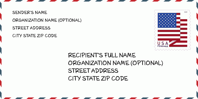
ที่อยู่ ตัวอย่าง
BLAIR NE 68008-5545
UNITED STATES OF AMERICA
68008-5545 ตัวอย่างซองจดหมาย

-
นี่คือตัวอย่างซองจดหมายของสหรัฐฯ กรอกข้อมูลผู้ส่งที่ด้านบนซ้ายและข้อมูลผู้รับที่ด้านล่างขวา ข้อมูลที่จำเป็นคือชื่อเต็มของผู้ส่ง/ผู้รับ ที่อยู่ เมือง รัฐ และรหัสไปรษณีย์ ข้อมูลที่อยู่ผู้รับได้รับสำหรับการอ้างอิงของคุณ โดยทั่วไป หากคุณไม่แน่ใจเกี่ยวกับรหัสไปรษณีย์ 9 หลักแบบเต็ม คุณสามารถกรอกรหัสไปรษณีย์ 5 หลักเท่านั้นเพื่อหลีกเลี่ยงการสูญหายของพัสดุ
68008-5545 ความหมายพื้นฐาน
-
รหัสไปรษณีย์ 68008-5545 แต่ละหลักย่อมาจากอะไร ? รหัสไปรษณีย์ประกอบด้วยสองส่วน โดยสามารถระบุหมายเลขห้าหลักแรกไปยังที่ทำการไปรษณีย์ได้ และตัวเลขสี่หลักสุดท้ายสามารถระบุส่วนทางภูมิศาสตร์ภายในพื้นที่จัดส่งห้าหลักได้ ตัวเลข 6-7 หลักกำหนดส่วนหรือหลายช่วงตึก และตัวเลข 8-9 หลักกำหนดส่วนหรือด้านใดด้านหนึ่งของถนน
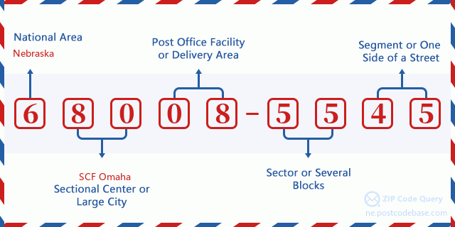

- · Idเส้นทางการขนส่ง?
A 4-digit code assigned to a mail delivery or collection route within a 5-digit ZIP Code. The first character of this identification is alphabetical, and the last three are numeric: Bnnn = PO box Hnnn = Highway contract Rnnn = Rural route Cnnn = City delivery Gnnn = General delivery: R001 (สายชนบท)
- ·ภาคต่ำเพิ่มเติมทางไปรษณีย์?
The ZIP Add-On Low Sector and the ZIP Add-On Low Segment together form the ZIP Add-On Low Number. The ZIP Add-On Low Number is the last four positions of a ZIP+4 code; the low-end ZIP add-on in a range of codes; the add-on of the first ZIP+4 code in a consecutive series of ZIP+4 codes assigned to the delivery address. For example, most delivery addresses are assigned a single ZIP+4 code. However, large companies may be given a range of ZIP+4 codes that can be used to route mail to specific departments. A range of ZIP+4 codes can also be assigned to a corresponding range of post office boxes, and each box is mapped, one-to-one, with a ZIP+4 code in the range. A single post office box can also be assigned a range of ZIP+4 codes.: 55
- ·ส่วนต่ำเพิ่มเติมทางไปรษณีย์?
The ZIP Add-On Low Sector and the ZIP Add-On Low Segment together form the ZIP Add-On Low Number. The ZIP Add-On Low Number is the last four positions of a ZIP+4 code; the low-end ZIP add-on in a range of codes; the add-on of the first ZIP+4 code in a consecutive series of ZIP+4 codes assigned to the delivery address. For example, most delivery addresses are assigned a single ZIP+4 code. However, large companies may be given a range of ZIP+4 codes that can be used to route mail to specific departments. A range of ZIP+4 codes can also be assigned to a corresponding range of post office boxes, and each box is mapped, one-to-one, with a ZIP+4 code in the range. A single post office box can also be assigned a range of ZIP+4 codes.: 45
- ·ภาคสูงเพิ่มเติมทางไปรษณีย์?
The ZIP Add-On High Sector and the ZIP Add-On High Segment together form the ZIP Add-On High Number, which is the high-end ZIP add-on in a range of codes; the add-on of the last ZIP+4 code in a consecutive series of ZIP+4 codes assigned to the delivery address. Most delivery addresses are assigned a single ZIP+4 code; however, large companies may be given a range of ZIP+4 codes that can be used to route mail to specific departments. A range of ZIP+4 codes can also be assigned to a corresponding range of post office boxes, and each box is mapped, one-to-one, with a ZIP+4 code in the range. A single post office box can also be assigned a range of ZIP+4 codes. (See also ZIP Add-On Code.): 55
- ·ส่วนสูงเพิ่มเติมทางไปรษณีย์?
The ZIP Add-On High Sector and the ZIP Add-On High Segment together form the ZIP Add-On High Number, which is the high-end ZIP add-on in a range of codes; the add-on of the last ZIP+4 code in a consecutive series of ZIP+4 codes assigned to the delivery address. Most delivery addresses are assigned a single ZIP+4 code; however, large companies may be given a range of ZIP+4 codes that can be used to route mail to specific departments. A range of ZIP+4 codes can also be assigned to a corresponding range of post office boxes, and each box is mapped, one-to-one, with a ZIP+4 code in the range. A single post office box can also be assigned a range of ZIP+4 codes. (See also ZIP Add-On Code.): 45
- ·รหัสไปรษณีย์ เพิ่มเติม: 5545
- ·เทือกเขา?
The range of +4 codes. Summing the +4 Code and the +4 Range will give you the high end of the range of +4 Codes that pertain to this ZIP Code.: 0
- ·รหัสแทนขั้นพื้นฐาน?
Code that specifies whether a record is a base (preferred) or alternate record. Base records (represented as "B") can represent a range of addresses or an individual address, such as a firm record, while alternate records (represented as "A") are individual delivery points. Government deliveries will only be listed on alternate records with the appropriate government building indicator (federal, state, or city) set.: พื้นฐาน
- ·ตัวเลขทางการเงิน?
A code assigned to Postal Service facilities (primarily post offices) to collect cost and statistical data and compile revenue and expense data. The state number comprises the first two positions of the finance number.: 301020
- ·ตัวเลขแขวงรัฐสภา?
A standard value identifying a geographic area within the United States served by a member of the US House of Representatives or Senate. If Army/Air Force (APO) or fleet post office (FPO), this column will be blank. If there is only one member of Congress within a state, the code will be "AL" (at large).: 01
- ·รหัสรัฐเมืองบรรทัดสุดท้าย?
An index to the City State file that provides the preferred last-line name for this address range.: W19528
แผนที่ออนไลน์

นี่คือแผนที่อิเล็กทรอนิกส์ออนไลน์ที่ที่อยู่ 18500 COUNTY ROAD P31 BLAIRจับคู่นั้น คุณสามารถจะใช้ปุ่มบนแผนที่เพื่อเลื่อนและซูม ข้อมูลแผนที่นี้ เฉพาะสำหรับการอ้างอิงเท่านั้น
ที่อยู่: 18500 (From 18500 To 18599) COUNTY ROAD P31, BLAIR, NE 68008-5545, USA
ความเห็น


แสดงความเห็น