地址: 4000 (From 4000 To 4099) W RD, ABIE, NE 68001-7002, USA
68001-7002是什么? 68001-7002是 4000 (From 4000 To 4099) W RD, ABIE, NE, USA的5加4位邮编。下面是详细信息。
68001-7002基本信息

-
邮政编码5加4:
68001-7002 -
邮政编码5:
68001 -
加4?70024-digits that are used to identify a geographic segment within the 5-digit delivery area, such as a city block or a group of apartments or an individual high-volume receiver of mail, or any other unit that could use an extra identifier to aid in efficient mail sorting and delivery. This code is the low end of the range of +4 Codes that pertain to this ZIP Code. ZIP+4 Codes associated with nondelivery areas are composed of valid ZIP sector numbers and "ND" for the ZIP segment number, for example 12345-12ND. Non-deliverable areas are areas to which the USPS does not deliver mail, such as vacant lots and land that borders railroad tracks. Mailers should not match an address identified as a nondelivery area. If you absolutely must have numeric characters in the Plus4Code column, you may treat "ND" values as "00" (zero zero).:
-
国家:
U.S. - 美国 -
州:
NE - 内布拉斯加州 -
区县:
CountyFIPS: 31023 - Butler County -
城市:
ABIE -
街道?W RDThe official name of a street as assigned by a local governing authority. The Street Name column contains only the street name and does not include directionals (EAST, WEST, etc.) or suffixes (ST, DR, BLVD, etc.). This element may also contain literals, such as PO BOX, GENERAL DELIVERY, USS, PSC, or UNIT. Numeric street names that have numeric components that are four characters (or less) in length at are justified such that the low-order digit of the number is positioned in the fourth position of the street name column. This shift is made so that the numeric street names appear in numeric sequence.:
-
街道后缀?RD (路街)The street suffix: For Example: ST = Street RD = Road DR = Drive LN = Lane:
-
记录类型?S: 街道An alphabetic value that identifies the type of data in the record. Record type codes include the following: G = General delivery H = Highrise F = Firm S = Street P = PO box R = Rural route/highway contract:
地址

- 主要地址低位数字?
A house, rural route, highway contract box, or post office box number; the numeric or alphanumeric component of an address preceding the street name; the low-end address in a range of addresses. Often referred to as house number.: 4000
- 主要地址高位数字?
A house, rural route, contract box, or Post Office box number. The numeric or alphanumeric component of an address preceding the street name. The high-end address in a range of addresses. Often referred to as house number.: 4099
- 主要地址奇/偶码?
Code that identifies the side or sides of a street for which a given address range is applicable. For street, highrise, firm and multi-carrier records, B = Both sides of a street, E = Even side of a street (even-numbered addresses in the range); O = Odd side of a street (odd-numbered addresses in the range). For general delivery, post office box, and rural route/highway contract records, this code will always be "B" (both).: Both of Odd and Even
- 主要范围: 4000, 4001, 4002, 4003, 4004, 4005, 4006, 4007, 4008, 4009, 4010, 4011, 4012, 4013, 4014, 4015, 4016, 4017, 4018, 4019, 4020, 4021, 4022, 4023, 4024, 4025, 4026, 4027, 4028, 4029, 4030, 4031, 4032, 4033, 4034, 4035, 4036, 4037, 4038, 4039, 4040, 4041, 4042, 4043, 4044, 4045, 4046, 4047, 4048, 4049, 4050, 4051, 4052, 4053, 4054, 4055, 4056, 4057, 4058, 4059, 4060, 4061, 4062, 4063, 4064, 4065, 4066, 4067, 4068, 4069, 4070, 4071, 4072, 4073, 4074, 4075, 4076, 4077, 4078, 4079, 4080, 4081, 4082, 4083, 4084, 4085, 4086, 4087, 4088, 4089, 4090, 4091, 4092, 4093, 4094, 4095, 4096, 4097, 4098, 4099.
请单击"更多地址示例"查看整个列表。
4000 W RD, ABIE, NE 68001-7002
4001 W RD, ABIE, NE 68001-7002
4002 W RD, ABIE, NE 68001-7002
4003 W RD, ABIE, NE 68001-7002
4004 W RD, ABIE, NE 68001-7002
4005 W RD, ABIE, NE 68001-7002
4006 W RD, ABIE, NE 68001-7002
4007 W RD, ABIE, NE 68001-7002
4008 W RD, ABIE, NE 68001-7002
4009 W RD, ABIE, NE 68001-7002
4010 W RD, ABIE, NE 68001-7002
4011 W RD, ABIE, NE 68001-7002
4012 W RD, ABIE, NE 68001-7002
4013 W RD, ABIE, NE 68001-7002
4014 W RD, ABIE, NE 68001-7002
4015 W RD, ABIE, NE 68001-7002
4016 W RD, ABIE, NE 68001-7002
4017 W RD, ABIE, NE 68001-7002
4018 W RD, ABIE, NE 68001-7002
4019 W RD, ABIE, NE 68001-7002
4020 W RD, ABIE, NE 68001-7002
4021 W RD, ABIE, NE 68001-7002
4022 W RD, ABIE, NE 68001-7002
4023 W RD, ABIE, NE 68001-7002
4024 W RD, ABIE, NE 68001-7002
4025 W RD, ABIE, NE 68001-7002
4026 W RD, ABIE, NE 68001-7002
4027 W RD, ABIE, NE 68001-7002
4028 W RD, ABIE, NE 68001-7002
4029 W RD, ABIE, NE 68001-7002
4030 W RD, ABIE, NE 68001-7002
4031 W RD, ABIE, NE 68001-7002
4032 W RD, ABIE, NE 68001-7002
4033 W RD, ABIE, NE 68001-7002
4034 W RD, ABIE, NE 68001-7002
4035 W RD, ABIE, NE 68001-7002
4036 W RD, ABIE, NE 68001-7002
4037 W RD, ABIE, NE 68001-7002
4038 W RD, ABIE, NE 68001-7002
4039 W RD, ABIE, NE 68001-7002
4040 W RD, ABIE, NE 68001-7002
4041 W RD, ABIE, NE 68001-7002
4042 W RD, ABIE, NE 68001-7002
4043 W RD, ABIE, NE 68001-7002
4044 W RD, ABIE, NE 68001-7002
4045 W RD, ABIE, NE 68001-7002
4046 W RD, ABIE, NE 68001-7002
4047 W RD, ABIE, NE 68001-7002
4048 W RD, ABIE, NE 68001-7002
4049 W RD, ABIE, NE 68001-7002
4050 W RD, ABIE, NE 68001-7002
4051 W RD, ABIE, NE 68001-7002
4052 W RD, ABIE, NE 68001-7002
4053 W RD, ABIE, NE 68001-7002
4054 W RD, ABIE, NE 68001-7002
4055 W RD, ABIE, NE 68001-7002
4056 W RD, ABIE, NE 68001-7002
4057 W RD, ABIE, NE 68001-7002
4058 W RD, ABIE, NE 68001-7002
4059 W RD, ABIE, NE 68001-7002
4060 W RD, ABIE, NE 68001-7002
4061 W RD, ABIE, NE 68001-7002
4062 W RD, ABIE, NE 68001-7002
4063 W RD, ABIE, NE 68001-7002
4064 W RD, ABIE, NE 68001-7002
4065 W RD, ABIE, NE 68001-7002
4066 W RD, ABIE, NE 68001-7002
4067 W RD, ABIE, NE 68001-7002
4068 W RD, ABIE, NE 68001-7002
4069 W RD, ABIE, NE 68001-7002
4070 W RD, ABIE, NE 68001-7002
4071 W RD, ABIE, NE 68001-7002
4072 W RD, ABIE, NE 68001-7002
4073 W RD, ABIE, NE 68001-7002
4074 W RD, ABIE, NE 68001-7002
4075 W RD, ABIE, NE 68001-7002
4076 W RD, ABIE, NE 68001-7002
4077 W RD, ABIE, NE 68001-7002
4078 W RD, ABIE, NE 68001-7002
4079 W RD, ABIE, NE 68001-7002
4080 W RD, ABIE, NE 68001-7002
4081 W RD, ABIE, NE 68001-7002
4082 W RD, ABIE, NE 68001-7002
4083 W RD, ABIE, NE 68001-7002
4084 W RD, ABIE, NE 68001-7002
4085 W RD, ABIE, NE 68001-7002
4086 W RD, ABIE, NE 68001-7002
4087 W RD, ABIE, NE 68001-7002
4088 W RD, ABIE, NE 68001-7002
4089 W RD, ABIE, NE 68001-7002
4090 W RD, ABIE, NE 68001-7002
4091 W RD, ABIE, NE 68001-7002
4092 W RD, ABIE, NE 68001-7002
4093 W RD, ABIE, NE 68001-7002
4094 W RD, ABIE, NE 68001-7002
4095 W RD, ABIE, NE 68001-7002
4096 W RD, ABIE, NE 68001-7002
4097 W RD, ABIE, NE 68001-7002
4098 W RD, ABIE, NE 68001-7002
4099 W RD, ABIE, NE 68001-7002
地址示例
ABIE NE 68001-7002
UNITED STATES OF AMERICA
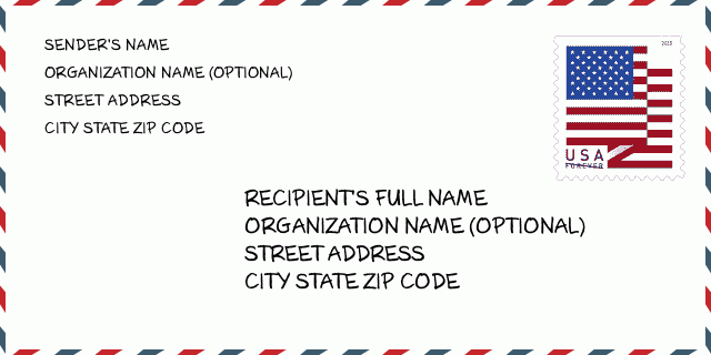
68001-7002信封例子

-
这是美国信封例子。在左上角填写发件人信息,右下角填写收件人信息。必须要填写的信息有发件人和收件人的姓名、街道地址、城市、州还有邮政编码。收件人的地址示例仅供参考。通常来说,如果你不确定九位邮件,你可以仅仅填写五位邮编,以避免邮件丢失。
68001-7002基本含义
-
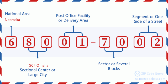
邮政编码 68001-7002 的每个数字代表什么?ZIP+4 Code由两部分组成,前五位数字可以定位到邮局,后四位数字可以确定五位数字递送区域内的一个地理区段。6-7位数字指定区域或几个街区,8-9位数字指定区段或街道的一侧。

- ·运输路线ID?
A 4-digit code assigned to a mail delivery or collection route within a 5-digit ZIP Code. The first character of this identification is alphabetical, and the last three are numeric: Bnnn = PO box Hnnn = Highway contract Rnnn = Rural route Cnnn = City delivery Gnnn = General delivery: R303 (农村线路)
- ·邮递附加低部?
The ZIP Add-On Low Sector and the ZIP Add-On Low Segment together form the ZIP Add-On Low Number. The ZIP Add-On Low Number is the last four positions of a ZIP+4 code; the low-end ZIP add-on in a range of codes; the add-on of the first ZIP+4 code in a consecutive series of ZIP+4 codes assigned to the delivery address. For example, most delivery addresses are assigned a single ZIP+4 code. However, large companies may be given a range of ZIP+4 codes that can be used to route mail to specific departments. A range of ZIP+4 codes can also be assigned to a corresponding range of post office boxes, and each box is mapped, one-to-one, with a ZIP+4 code in the range. A single post office box can also be assigned a range of ZIP+4 codes.: 70
- ·邮递附加低段?
The ZIP Add-On Low Sector and the ZIP Add-On Low Segment together form the ZIP Add-On Low Number. The ZIP Add-On Low Number is the last four positions of a ZIP+4 code; the low-end ZIP add-on in a range of codes; the add-on of the first ZIP+4 code in a consecutive series of ZIP+4 codes assigned to the delivery address. For example, most delivery addresses are assigned a single ZIP+4 code. However, large companies may be given a range of ZIP+4 codes that can be used to route mail to specific departments. A range of ZIP+4 codes can also be assigned to a corresponding range of post office boxes, and each box is mapped, one-to-one, with a ZIP+4 code in the range. A single post office box can also be assigned a range of ZIP+4 codes.: 02
- ·邮递附加高部?
The ZIP Add-On High Sector and the ZIP Add-On High Segment together form the ZIP Add-On High Number, which is the high-end ZIP add-on in a range of codes; the add-on of the last ZIP+4 code in a consecutive series of ZIP+4 codes assigned to the delivery address. Most delivery addresses are assigned a single ZIP+4 code; however, large companies may be given a range of ZIP+4 codes that can be used to route mail to specific departments. A range of ZIP+4 codes can also be assigned to a corresponding range of post office boxes, and each box is mapped, one-to-one, with a ZIP+4 code in the range. A single post office box can also be assigned a range of ZIP+4 codes. (See also ZIP Add-On Code.): 70
- ·邮递附加高段?
The ZIP Add-On High Sector and the ZIP Add-On High Segment together form the ZIP Add-On High Number, which is the high-end ZIP add-on in a range of codes; the add-on of the last ZIP+4 code in a consecutive series of ZIP+4 codes assigned to the delivery address. Most delivery addresses are assigned a single ZIP+4 code; however, large companies may be given a range of ZIP+4 codes that can be used to route mail to specific departments. A range of ZIP+4 codes can also be assigned to a corresponding range of post office boxes, and each box is mapped, one-to-one, with a ZIP+4 code in the range. A single post office box can also be assigned a range of ZIP+4 codes. (See also ZIP Add-On Code.): 02
- ·邮编附加: 7002
- ·范围?
The range of +4 codes. Summing the +4 Code and the +4 Range will give you the high end of the range of +4 Codes that pertain to this ZIP Code.: 0
- ·基本替代代码?
Code that specifies whether a record is a base (preferred) or alternate record. Base records (represented as "B") can represent a range of addresses or an individual address, such as a firm record, while alternate records (represented as "A") are individual delivery points. Government deliveries will only be listed on alternate records with the appropriate government building indicator (federal, state, or city) set.: 基本
- ·财务数字?
A code assigned to Postal Service facilities (primarily post offices) to collect cost and statistical data and compile revenue and expense data. The state number comprises the first two positions of the finance number.: 309375
- ·国会分区数字?
A standard value identifying a geographic area within the United States served by a member of the US House of Representatives or Senate. If Army/Air Force (APO) or fleet post office (FPO), this column will be blank. If there is only one member of Congress within a state, the code will be "AL" (at large).: 01
- ·最后行城市州代码?
An index to the City State file that provides the preferred last-line name for this address range.: W19431
在线地图

这是地址4000 W RD, ABIE匹配的在线电子地图。您可以使用图中按钮来移动、缩放。该地图信息仅供参考。
地址: 4000 (From 4000 To 4099) W RD, ABIE, NE 68001-7002, USA
评论


