地址: 7400 (From 7400 To 7499) COUNTY ROAD P35, BLAIR, NE 68008-6563, USA
68008-6563是什么? 68008-6563是 7400 (From 7400 To 7499) COUNTY ROAD P35, BLAIR, NE, USA的5加4位邮编。下面是详细信息。
68008-6563基本信息

-
邮政编码5加4:
68008-6563 -
邮政编码5:
68008 -
加4?65634-digits that are used to identify a geographic segment within the 5-digit delivery area, such as a city block or a group of apartments or an individual high-volume receiver of mail, or any other unit that could use an extra identifier to aid in efficient mail sorting and delivery. This code is the low end of the range of +4 Codes that pertain to this ZIP Code. ZIP+4 Codes associated with nondelivery areas are composed of valid ZIP sector numbers and "ND" for the ZIP segment number, for example 12345-12ND. Non-deliverable areas are areas to which the USPS does not deliver mail, such as vacant lots and land that borders railroad tracks. Mailers should not match an address identified as a nondelivery area. If you absolutely must have numeric characters in the Plus4Code column, you may treat "ND" values as "00" (zero zero).:
-
国家:
U.S. - 美国 -
州:
NE - 内布拉斯加州 -
区县:
CountyFIPS: 31177 - Washington County -
城市:
BLAIR -
街道?COUNTY ROAD P35The official name of a street as assigned by a local governing authority. The Street Name column contains only the street name and does not include directionals (EAST, WEST, etc.) or suffixes (ST, DR, BLVD, etc.). This element may also contain literals, such as PO BOX, GENERAL DELIVERY, USS, PSC, or UNIT. Numeric street names that have numeric components that are four characters (or less) in length at are justified such that the low-order digit of the number is positioned in the fourth position of the street name column. This shift is made so that the numeric street names appear in numeric sequence.:
-
记录类型?S: 街道An alphabetic value that identifies the type of data in the record. Record type codes include the following: G = General delivery H = Highrise F = Firm S = Street P = PO box R = Rural route/highway contract:
地址

- 主要地址低位数字?
A house, rural route, highway contract box, or post office box number; the numeric or alphanumeric component of an address preceding the street name; the low-end address in a range of addresses. Often referred to as house number.: 7400
- 主要地址高位数字?
A house, rural route, contract box, or Post Office box number. The numeric or alphanumeric component of an address preceding the street name. The high-end address in a range of addresses. Often referred to as house number.: 7499
- 主要地址奇/偶码?
Code that identifies the side or sides of a street for which a given address range is applicable. For street, highrise, firm and multi-carrier records, B = Both sides of a street, E = Even side of a street (even-numbered addresses in the range); O = Odd side of a street (odd-numbered addresses in the range). For general delivery, post office box, and rural route/highway contract records, this code will always be "B" (both).: Both of Odd and Even
- 主要范围: 7400, 7401, 7402, 7403, 7404, 7405, 7406, 7407, 7408, 7409, 7410, 7411, 7412, 7413, 7414, 7415, 7416, 7417, 7418, 7419, 7420, 7421, 7422, 7423, 7424, 7425, 7426, 7427, 7428, 7429, 7430, 7431, 7432, 7433, 7434, 7435, 7436, 7437, 7438, 7439, 7440, 7441, 7442, 7443, 7444, 7445, 7446, 7447, 7448, 7449, 7450, 7451, 7452, 7453, 7454, 7455, 7456, 7457, 7458, 7459, 7460, 7461, 7462, 7463, 7464, 7465, 7466, 7467, 7468, 7469, 7470, 7471, 7472, 7473, 7474, 7475, 7476, 7477, 7478, 7479, 7480, 7481, 7482, 7483, 7484, 7485, 7486, 7487, 7488, 7489, 7490, 7491, 7492, 7493, 7494, 7495, 7496, 7497, 7498, 7499.
请单击"更多地址示例"查看整个列表。
7400 COUNTY ROAD P35, BLAIR, NE 68008-6563
7401 COUNTY ROAD P35, BLAIR, NE 68008-6563
7402 COUNTY ROAD P35, BLAIR, NE 68008-6563
7403 COUNTY ROAD P35, BLAIR, NE 68008-6563
7404 COUNTY ROAD P35, BLAIR, NE 68008-6563
7405 COUNTY ROAD P35, BLAIR, NE 68008-6563
7406 COUNTY ROAD P35, BLAIR, NE 68008-6563
7407 COUNTY ROAD P35, BLAIR, NE 68008-6563
7408 COUNTY ROAD P35, BLAIR, NE 68008-6563
7409 COUNTY ROAD P35, BLAIR, NE 68008-6563
7410 COUNTY ROAD P35, BLAIR, NE 68008-6563
7411 COUNTY ROAD P35, BLAIR, NE 68008-6563
7412 COUNTY ROAD P35, BLAIR, NE 68008-6563
7413 COUNTY ROAD P35, BLAIR, NE 68008-6563
7414 COUNTY ROAD P35, BLAIR, NE 68008-6563
7415 COUNTY ROAD P35, BLAIR, NE 68008-6563
7416 COUNTY ROAD P35, BLAIR, NE 68008-6563
7417 COUNTY ROAD P35, BLAIR, NE 68008-6563
7418 COUNTY ROAD P35, BLAIR, NE 68008-6563
7419 COUNTY ROAD P35, BLAIR, NE 68008-6563
7420 COUNTY ROAD P35, BLAIR, NE 68008-6563
7421 COUNTY ROAD P35, BLAIR, NE 68008-6563
7422 COUNTY ROAD P35, BLAIR, NE 68008-6563
7423 COUNTY ROAD P35, BLAIR, NE 68008-6563
7424 COUNTY ROAD P35, BLAIR, NE 68008-6563
7425 COUNTY ROAD P35, BLAIR, NE 68008-6563
7426 COUNTY ROAD P35, BLAIR, NE 68008-6563
7427 COUNTY ROAD P35, BLAIR, NE 68008-6563
7428 COUNTY ROAD P35, BLAIR, NE 68008-6563
7429 COUNTY ROAD P35, BLAIR, NE 68008-6563
7430 COUNTY ROAD P35, BLAIR, NE 68008-6563
7431 COUNTY ROAD P35, BLAIR, NE 68008-6563
7432 COUNTY ROAD P35, BLAIR, NE 68008-6563
7433 COUNTY ROAD P35, BLAIR, NE 68008-6563
7434 COUNTY ROAD P35, BLAIR, NE 68008-6563
7435 COUNTY ROAD P35, BLAIR, NE 68008-6563
7436 COUNTY ROAD P35, BLAIR, NE 68008-6563
7437 COUNTY ROAD P35, BLAIR, NE 68008-6563
7438 COUNTY ROAD P35, BLAIR, NE 68008-6563
7439 COUNTY ROAD P35, BLAIR, NE 68008-6563
7440 COUNTY ROAD P35, BLAIR, NE 68008-6563
7441 COUNTY ROAD P35, BLAIR, NE 68008-6563
7442 COUNTY ROAD P35, BLAIR, NE 68008-6563
7443 COUNTY ROAD P35, BLAIR, NE 68008-6563
7444 COUNTY ROAD P35, BLAIR, NE 68008-6563
7445 COUNTY ROAD P35, BLAIR, NE 68008-6563
7446 COUNTY ROAD P35, BLAIR, NE 68008-6563
7447 COUNTY ROAD P35, BLAIR, NE 68008-6563
7448 COUNTY ROAD P35, BLAIR, NE 68008-6563
7449 COUNTY ROAD P35, BLAIR, NE 68008-6563
7450 COUNTY ROAD P35, BLAIR, NE 68008-6563
7451 COUNTY ROAD P35, BLAIR, NE 68008-6563
7452 COUNTY ROAD P35, BLAIR, NE 68008-6563
7453 COUNTY ROAD P35, BLAIR, NE 68008-6563
7454 COUNTY ROAD P35, BLAIR, NE 68008-6563
7455 COUNTY ROAD P35, BLAIR, NE 68008-6563
7456 COUNTY ROAD P35, BLAIR, NE 68008-6563
7457 COUNTY ROAD P35, BLAIR, NE 68008-6563
7458 COUNTY ROAD P35, BLAIR, NE 68008-6563
7459 COUNTY ROAD P35, BLAIR, NE 68008-6563
7460 COUNTY ROAD P35, BLAIR, NE 68008-6563
7461 COUNTY ROAD P35, BLAIR, NE 68008-6563
7462 COUNTY ROAD P35, BLAIR, NE 68008-6563
7463 COUNTY ROAD P35, BLAIR, NE 68008-6563
7464 COUNTY ROAD P35, BLAIR, NE 68008-6563
7465 COUNTY ROAD P35, BLAIR, NE 68008-6563
7466 COUNTY ROAD P35, BLAIR, NE 68008-6563
7467 COUNTY ROAD P35, BLAIR, NE 68008-6563
7468 COUNTY ROAD P35, BLAIR, NE 68008-6563
7469 COUNTY ROAD P35, BLAIR, NE 68008-6563
7470 COUNTY ROAD P35, BLAIR, NE 68008-6563
7471 COUNTY ROAD P35, BLAIR, NE 68008-6563
7472 COUNTY ROAD P35, BLAIR, NE 68008-6563
7473 COUNTY ROAD P35, BLAIR, NE 68008-6563
7474 COUNTY ROAD P35, BLAIR, NE 68008-6563
7475 COUNTY ROAD P35, BLAIR, NE 68008-6563
7476 COUNTY ROAD P35, BLAIR, NE 68008-6563
7477 COUNTY ROAD P35, BLAIR, NE 68008-6563
7478 COUNTY ROAD P35, BLAIR, NE 68008-6563
7479 COUNTY ROAD P35, BLAIR, NE 68008-6563
7480 COUNTY ROAD P35, BLAIR, NE 68008-6563
7481 COUNTY ROAD P35, BLAIR, NE 68008-6563
7482 COUNTY ROAD P35, BLAIR, NE 68008-6563
7483 COUNTY ROAD P35, BLAIR, NE 68008-6563
7484 COUNTY ROAD P35, BLAIR, NE 68008-6563
7485 COUNTY ROAD P35, BLAIR, NE 68008-6563
7486 COUNTY ROAD P35, BLAIR, NE 68008-6563
7487 COUNTY ROAD P35, BLAIR, NE 68008-6563
7488 COUNTY ROAD P35, BLAIR, NE 68008-6563
7489 COUNTY ROAD P35, BLAIR, NE 68008-6563
7490 COUNTY ROAD P35, BLAIR, NE 68008-6563
7491 COUNTY ROAD P35, BLAIR, NE 68008-6563
7492 COUNTY ROAD P35, BLAIR, NE 68008-6563
7493 COUNTY ROAD P35, BLAIR, NE 68008-6563
7494 COUNTY ROAD P35, BLAIR, NE 68008-6563
7495 COUNTY ROAD P35, BLAIR, NE 68008-6563
7496 COUNTY ROAD P35, BLAIR, NE 68008-6563
7497 COUNTY ROAD P35, BLAIR, NE 68008-6563
7498 COUNTY ROAD P35, BLAIR, NE 68008-6563
7499 COUNTY ROAD P35, BLAIR, NE 68008-6563
地址示例
BLAIR NE 68008-6563
UNITED STATES OF AMERICA
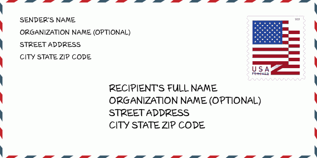
68008-6563信封例子

-
这是美国信封例子。在左上角填写发件人信息,右下角填写收件人信息。必须要填写的信息有发件人和收件人的姓名、街道地址、城市、州还有邮政编码。收件人的地址示例仅供参考。通常来说,如果你不确定九位邮件,你可以仅仅填写五位邮编,以避免邮件丢失。
68008-6563基本含义
-
邮政编码 68008-6563 的每个数字代表什么?ZIP+4 Code由两部分组成,前五位数字可以定位到邮局,后四位数字可以确定五位数字递送区域内的一个地理区段。6-7位数字指定区域或几个街区,8-9位数字指定区段或街道的一侧。
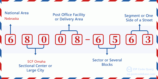

- ·运输路线ID?
A 4-digit code assigned to a mail delivery or collection route within a 5-digit ZIP Code. The first character of this identification is alphabetical, and the last three are numeric: Bnnn = PO box Hnnn = Highway contract Rnnn = Rural route Cnnn = City delivery Gnnn = General delivery: R003 (农村线路)
- ·邮递附加低部?
The ZIP Add-On Low Sector and the ZIP Add-On Low Segment together form the ZIP Add-On Low Number. The ZIP Add-On Low Number is the last four positions of a ZIP+4 code; the low-end ZIP add-on in a range of codes; the add-on of the first ZIP+4 code in a consecutive series of ZIP+4 codes assigned to the delivery address. For example, most delivery addresses are assigned a single ZIP+4 code. However, large companies may be given a range of ZIP+4 codes that can be used to route mail to specific departments. A range of ZIP+4 codes can also be assigned to a corresponding range of post office boxes, and each box is mapped, one-to-one, with a ZIP+4 code in the range. A single post office box can also be assigned a range of ZIP+4 codes.: 65
- ·邮递附加低段?
The ZIP Add-On Low Sector and the ZIP Add-On Low Segment together form the ZIP Add-On Low Number. The ZIP Add-On Low Number is the last four positions of a ZIP+4 code; the low-end ZIP add-on in a range of codes; the add-on of the first ZIP+4 code in a consecutive series of ZIP+4 codes assigned to the delivery address. For example, most delivery addresses are assigned a single ZIP+4 code. However, large companies may be given a range of ZIP+4 codes that can be used to route mail to specific departments. A range of ZIP+4 codes can also be assigned to a corresponding range of post office boxes, and each box is mapped, one-to-one, with a ZIP+4 code in the range. A single post office box can also be assigned a range of ZIP+4 codes.: 63
- ·邮递附加高部?
The ZIP Add-On High Sector and the ZIP Add-On High Segment together form the ZIP Add-On High Number, which is the high-end ZIP add-on in a range of codes; the add-on of the last ZIP+4 code in a consecutive series of ZIP+4 codes assigned to the delivery address. Most delivery addresses are assigned a single ZIP+4 code; however, large companies may be given a range of ZIP+4 codes that can be used to route mail to specific departments. A range of ZIP+4 codes can also be assigned to a corresponding range of post office boxes, and each box is mapped, one-to-one, with a ZIP+4 code in the range. A single post office box can also be assigned a range of ZIP+4 codes. (See also ZIP Add-On Code.): 65
- ·邮递附加高段?
The ZIP Add-On High Sector and the ZIP Add-On High Segment together form the ZIP Add-On High Number, which is the high-end ZIP add-on in a range of codes; the add-on of the last ZIP+4 code in a consecutive series of ZIP+4 codes assigned to the delivery address. Most delivery addresses are assigned a single ZIP+4 code; however, large companies may be given a range of ZIP+4 codes that can be used to route mail to specific departments. A range of ZIP+4 codes can also be assigned to a corresponding range of post office boxes, and each box is mapped, one-to-one, with a ZIP+4 code in the range. A single post office box can also be assigned a range of ZIP+4 codes. (See also ZIP Add-On Code.): 63
- ·邮编附加: 6563
- ·范围?
The range of +4 codes. Summing the +4 Code and the +4 Range will give you the high end of the range of +4 Codes that pertain to this ZIP Code.: 0
- ·基本替代代码?
Code that specifies whether a record is a base (preferred) or alternate record. Base records (represented as "B") can represent a range of addresses or an individual address, such as a firm record, while alternate records (represented as "A") are individual delivery points. Government deliveries will only be listed on alternate records with the appropriate government building indicator (federal, state, or city) set.: 基本
- ·财务数字?
A code assigned to Postal Service facilities (primarily post offices) to collect cost and statistical data and compile revenue and expense data. The state number comprises the first two positions of the finance number.: 301020
- ·国会分区数字?
A standard value identifying a geographic area within the United States served by a member of the US House of Representatives or Senate. If Army/Air Force (APO) or fleet post office (FPO), this column will be blank. If there is only one member of Congress within a state, the code will be "AL" (at large).: 01
- ·最后行城市州代码?
An index to the City State file that provides the preferred last-line name for this address range.: W19528
在线地图

这是地址7400 COUNTY ROAD P35 BLAIR匹配的在线电子地图。您可以使用图中按钮来移动、缩放。该地图信息仅供参考。
地址: 7400 (From 7400 To 7499) COUNTY ROAD P35, BLAIR, NE 68008-6563, USA
评论


添加新评论