地址: 19700 (From 19700 To 19799) COUNTY ROAD 16, BLAIR, NE 68008-5590, USA
68008-5590是什麼 68008-5590是 19700 (From 19700 To 19799) COUNTY ROAD 16, BLAIR, NE, USA的5加4位邮编。下面是详细信息。
68008-5590基本信息

-
郵政編碼5加4:
68008-5590 -
郵政編碼5:
68008 -
加4?55904-digits that are used to identify a geographic segment within the 5-digit delivery area, such as a city block or a group of apartments or an individual high-volume receiver of mail, or any other unit that could use an extra identifier to aid in efficient mail sorting and delivery. This code is the low end of the range of +4 Codes that pertain to this ZIP Code. ZIP+4 Codes associated with nondelivery areas are composed of valid ZIP sector numbers and "ND" for the ZIP segment number, for example 12345-12ND. Non-deliverable areas are areas to which the USPS does not deliver mail, such as vacant lots and land that borders railroad tracks. Mailers should not match an address identified as a nondelivery area. If you absolutely must have numeric characters in the Plus4Code column, you may treat "ND" values as "00" (zero zero).:
-
國家:
U.S. - 美國 -
州:
NE - 內布拉斯加州 -
區縣:
CountyFIPS: 31177 - Washington County -
城市:
BLAIR -
街道?COUNTY ROAD 16The official name of a street as assigned by a local governing authority. The Street Name column contains only the street name and does not include directionals (EAST, WEST, etc.) or suffixes (ST, DR, BLVD, etc.). This element may also contain literals, such as PO BOX, GENERAL DELIVERY, USS, PSC, or UNIT. Numeric street names that have numeric components that are four characters (or less) in length at are justified such that the low-order digit of the number is positioned in the fourth position of the street name column. This shift is made so that the numeric street names appear in numeric sequence.:
-
記錄類型?S: 街道An alphabetic value that identifies the type of data in the record. Record type codes include the following: G = General delivery H = Highrise F = Firm S = Street P = PO box R = Rural route/highway contract:
地址

- 主要地址地位數字?
A house, rural route, highway contract box, or post office box number; the numeric or alphanumeric component of an address preceding the street name; the low-end address in a range of addresses. Often referred to as house number.: 19700
- 主要地址高位數字?
A house, rural route, contract box, or Post Office box number. The numeric or alphanumeric component of an address preceding the street name. The high-end address in a range of addresses. Often referred to as house number.: 19799
- 主要地址奇/偶碼?
Code that identifies the side or sides of a street for which a given address range is applicable. For street, highrise, firm and multi-carrier records, B = Both sides of a street, E = Even side of a street (even-numbered addresses in the range); O = Odd side of a street (odd-numbered addresses in the range). For general delivery, post office box, and rural route/highway contract records, this code will always be "B" (both).: Both of Odd and Even
- 主要範圍: 19700, 19701, 19702, 19703, 19704, 19705, 19706, 19707, 19708, 19709, 19710, 19711, 19712, 19713, 19714, 19715, 19716, 19717, 19718, 19719, 19720, 19721, 19722, 19723, 19724, 19725, 19726, 19727, 19728, 19729, 19730, 19731, 19732, 19733, 19734, 19735, 19736, 19737, 19738, 19739, 19740, 19741, 19742, 19743, 19744, 19745, 19746, 19747, 19748, 19749, 19750, 19751, 19752, 19753, 19754, 19755, 19756, 19757, 19758, 19759, 19760, 19761, 19762, 19763, 19764, 19765, 19766, 19767, 19768, 19769, 19770, 19771, 19772, 19773, 19774, 19775, 19776, 19777, 19778, 19779, 19780, 19781, 19782, 19783, 19784, 19785, 19786, 19787, 19788, 19789, 19790, 19791, 19792, 19793, 19794, 19795, 19796, 19797, 19798, 19799.
請單擊"更多地址示例"查看整個列表。
19700 COUNTY ROAD 16, BLAIR, NE 68008-5590
19701 COUNTY ROAD 16, BLAIR, NE 68008-5590
19702 COUNTY ROAD 16, BLAIR, NE 68008-5590
19703 COUNTY ROAD 16, BLAIR, NE 68008-5590
19704 COUNTY ROAD 16, BLAIR, NE 68008-5590
19705 COUNTY ROAD 16, BLAIR, NE 68008-5590
19706 COUNTY ROAD 16, BLAIR, NE 68008-5590
19707 COUNTY ROAD 16, BLAIR, NE 68008-5590
19708 COUNTY ROAD 16, BLAIR, NE 68008-5590
19709 COUNTY ROAD 16, BLAIR, NE 68008-5590
19710 COUNTY ROAD 16, BLAIR, NE 68008-5590
19711 COUNTY ROAD 16, BLAIR, NE 68008-5590
19712 COUNTY ROAD 16, BLAIR, NE 68008-5590
19713 COUNTY ROAD 16, BLAIR, NE 68008-5590
19714 COUNTY ROAD 16, BLAIR, NE 68008-5590
19715 COUNTY ROAD 16, BLAIR, NE 68008-5590
19716 COUNTY ROAD 16, BLAIR, NE 68008-5590
19717 COUNTY ROAD 16, BLAIR, NE 68008-5590
19718 COUNTY ROAD 16, BLAIR, NE 68008-5590
19719 COUNTY ROAD 16, BLAIR, NE 68008-5590
19720 COUNTY ROAD 16, BLAIR, NE 68008-5590
19721 COUNTY ROAD 16, BLAIR, NE 68008-5590
19722 COUNTY ROAD 16, BLAIR, NE 68008-5590
19723 COUNTY ROAD 16, BLAIR, NE 68008-5590
19724 COUNTY ROAD 16, BLAIR, NE 68008-5590
19725 COUNTY ROAD 16, BLAIR, NE 68008-5590
19726 COUNTY ROAD 16, BLAIR, NE 68008-5590
19727 COUNTY ROAD 16, BLAIR, NE 68008-5590
19728 COUNTY ROAD 16, BLAIR, NE 68008-5590
19729 COUNTY ROAD 16, BLAIR, NE 68008-5590
19730 COUNTY ROAD 16, BLAIR, NE 68008-5590
19731 COUNTY ROAD 16, BLAIR, NE 68008-5590
19732 COUNTY ROAD 16, BLAIR, NE 68008-5590
19733 COUNTY ROAD 16, BLAIR, NE 68008-5590
19734 COUNTY ROAD 16, BLAIR, NE 68008-5590
19735 COUNTY ROAD 16, BLAIR, NE 68008-5590
19736 COUNTY ROAD 16, BLAIR, NE 68008-5590
19737 COUNTY ROAD 16, BLAIR, NE 68008-5590
19738 COUNTY ROAD 16, BLAIR, NE 68008-5590
19739 COUNTY ROAD 16, BLAIR, NE 68008-5590
19740 COUNTY ROAD 16, BLAIR, NE 68008-5590
19741 COUNTY ROAD 16, BLAIR, NE 68008-5590
19742 COUNTY ROAD 16, BLAIR, NE 68008-5590
19743 COUNTY ROAD 16, BLAIR, NE 68008-5590
19744 COUNTY ROAD 16, BLAIR, NE 68008-5590
19745 COUNTY ROAD 16, BLAIR, NE 68008-5590
19746 COUNTY ROAD 16, BLAIR, NE 68008-5590
19747 COUNTY ROAD 16, BLAIR, NE 68008-5590
19748 COUNTY ROAD 16, BLAIR, NE 68008-5590
19749 COUNTY ROAD 16, BLAIR, NE 68008-5590
19750 COUNTY ROAD 16, BLAIR, NE 68008-5590
19751 COUNTY ROAD 16, BLAIR, NE 68008-5590
19752 COUNTY ROAD 16, BLAIR, NE 68008-5590
19753 COUNTY ROAD 16, BLAIR, NE 68008-5590
19754 COUNTY ROAD 16, BLAIR, NE 68008-5590
19755 COUNTY ROAD 16, BLAIR, NE 68008-5590
19756 COUNTY ROAD 16, BLAIR, NE 68008-5590
19757 COUNTY ROAD 16, BLAIR, NE 68008-5590
19758 COUNTY ROAD 16, BLAIR, NE 68008-5590
19759 COUNTY ROAD 16, BLAIR, NE 68008-5590
19760 COUNTY ROAD 16, BLAIR, NE 68008-5590
19761 COUNTY ROAD 16, BLAIR, NE 68008-5590
19762 COUNTY ROAD 16, BLAIR, NE 68008-5590
19763 COUNTY ROAD 16, BLAIR, NE 68008-5590
19764 COUNTY ROAD 16, BLAIR, NE 68008-5590
19765 COUNTY ROAD 16, BLAIR, NE 68008-5590
19766 COUNTY ROAD 16, BLAIR, NE 68008-5590
19767 COUNTY ROAD 16, BLAIR, NE 68008-5590
19768 COUNTY ROAD 16, BLAIR, NE 68008-5590
19769 COUNTY ROAD 16, BLAIR, NE 68008-5590
19770 COUNTY ROAD 16, BLAIR, NE 68008-5590
19771 COUNTY ROAD 16, BLAIR, NE 68008-5590
19772 COUNTY ROAD 16, BLAIR, NE 68008-5590
19773 COUNTY ROAD 16, BLAIR, NE 68008-5590
19774 COUNTY ROAD 16, BLAIR, NE 68008-5590
19775 COUNTY ROAD 16, BLAIR, NE 68008-5590
19776 COUNTY ROAD 16, BLAIR, NE 68008-5590
19777 COUNTY ROAD 16, BLAIR, NE 68008-5590
19778 COUNTY ROAD 16, BLAIR, NE 68008-5590
19779 COUNTY ROAD 16, BLAIR, NE 68008-5590
19780 COUNTY ROAD 16, BLAIR, NE 68008-5590
19781 COUNTY ROAD 16, BLAIR, NE 68008-5590
19782 COUNTY ROAD 16, BLAIR, NE 68008-5590
19783 COUNTY ROAD 16, BLAIR, NE 68008-5590
19784 COUNTY ROAD 16, BLAIR, NE 68008-5590
19785 COUNTY ROAD 16, BLAIR, NE 68008-5590
19786 COUNTY ROAD 16, BLAIR, NE 68008-5590
19787 COUNTY ROAD 16, BLAIR, NE 68008-5590
19788 COUNTY ROAD 16, BLAIR, NE 68008-5590
19789 COUNTY ROAD 16, BLAIR, NE 68008-5590
19790 COUNTY ROAD 16, BLAIR, NE 68008-5590
19791 COUNTY ROAD 16, BLAIR, NE 68008-5590
19792 COUNTY ROAD 16, BLAIR, NE 68008-5590
19793 COUNTY ROAD 16, BLAIR, NE 68008-5590
19794 COUNTY ROAD 16, BLAIR, NE 68008-5590
19795 COUNTY ROAD 16, BLAIR, NE 68008-5590
19796 COUNTY ROAD 16, BLAIR, NE 68008-5590
19797 COUNTY ROAD 16, BLAIR, NE 68008-5590
19798 COUNTY ROAD 16, BLAIR, NE 68008-5590
19799 COUNTY ROAD 16, BLAIR, NE 68008-5590
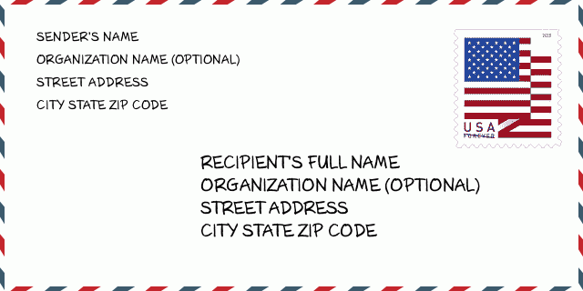
地址範例
BLAIR NE 68008-5590
UNITED STATES OF AMERICA
68008-5590信封例子

-
這是美國信封例子。在左上角填寫發件人信息,右下角填寫收件人信息。必須要填寫的信息有發件人和收件人的姓名、街道地址、城市、州還有郵政編碼。收件人的地址示例僅供參考。通常來說,如果你不確定九位郵件,你可以僅僅填寫五位郵編,以避免郵件丟失。
68008-5590基本含義
-
郵政編碼 68008-5590 的每個數字代表什麼?ZIP+4 Code由兩部分組成,前五位數字可以定位到郵局,後四位數字可以確定五位數字遞送區域內的一個地理區段。 6-7位數字指定區域或幾個街區,8-9位數字指定區段或街道的一側。
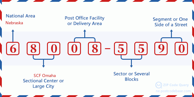

- ·運輸路線ID?
A 4-digit code assigned to a mail delivery or collection route within a 5-digit ZIP Code. The first character of this identification is alphabetical, and the last three are numeric: Bnnn = PO box Hnnn = Highway contract Rnnn = Rural route Cnnn = City delivery Gnnn = General delivery: R001 (農村路線)
- ·郵遞附加低部?
The ZIP Add-On Low Sector and the ZIP Add-On Low Segment together form the ZIP Add-On Low Number. The ZIP Add-On Low Number is the last four positions of a ZIP+4 code; the low-end ZIP add-on in a range of codes; the add-on of the first ZIP+4 code in a consecutive series of ZIP+4 codes assigned to the delivery address. For example, most delivery addresses are assigned a single ZIP+4 code. However, large companies may be given a range of ZIP+4 codes that can be used to route mail to specific departments. A range of ZIP+4 codes can also be assigned to a corresponding range of post office boxes, and each box is mapped, one-to-one, with a ZIP+4 code in the range. A single post office box can also be assigned a range of ZIP+4 codes.: 55
- ·郵遞附加低段?
The ZIP Add-On Low Sector and the ZIP Add-On Low Segment together form the ZIP Add-On Low Number. The ZIP Add-On Low Number is the last four positions of a ZIP+4 code; the low-end ZIP add-on in a range of codes; the add-on of the first ZIP+4 code in a consecutive series of ZIP+4 codes assigned to the delivery address. For example, most delivery addresses are assigned a single ZIP+4 code. However, large companies may be given a range of ZIP+4 codes that can be used to route mail to specific departments. A range of ZIP+4 codes can also be assigned to a corresponding range of post office boxes, and each box is mapped, one-to-one, with a ZIP+4 code in the range. A single post office box can also be assigned a range of ZIP+4 codes.: 90
- ·郵遞附加高部?
The ZIP Add-On High Sector and the ZIP Add-On High Segment together form the ZIP Add-On High Number, which is the high-end ZIP add-on in a range of codes; the add-on of the last ZIP+4 code in a consecutive series of ZIP+4 codes assigned to the delivery address. Most delivery addresses are assigned a single ZIP+4 code; however, large companies may be given a range of ZIP+4 codes that can be used to route mail to specific departments. A range of ZIP+4 codes can also be assigned to a corresponding range of post office boxes, and each box is mapped, one-to-one, with a ZIP+4 code in the range. A single post office box can also be assigned a range of ZIP+4 codes. (See also ZIP Add-On Code.): 55
- ·郵遞附加高段?
The ZIP Add-On High Sector and the ZIP Add-On High Segment together form the ZIP Add-On High Number, which is the high-end ZIP add-on in a range of codes; the add-on of the last ZIP+4 code in a consecutive series of ZIP+4 codes assigned to the delivery address. Most delivery addresses are assigned a single ZIP+4 code; however, large companies may be given a range of ZIP+4 codes that can be used to route mail to specific departments. A range of ZIP+4 codes can also be assigned to a corresponding range of post office boxes, and each box is mapped, one-to-one, with a ZIP+4 code in the range. A single post office box can also be assigned a range of ZIP+4 codes. (See also ZIP Add-On Code.): 90
- ·郵政編碼附加: 5590
- ·範圍?
The range of +4 codes. Summing the +4 Code and the +4 Range will give you the high end of the range of +4 Codes that pertain to this ZIP Code.: 0
- ·基本替代代碼?
Code that specifies whether a record is a base (preferred) or alternate record. Base records (represented as "B") can represent a range of addresses or an individual address, such as a firm record, while alternate records (represented as "A") are individual delivery points. Government deliveries will only be listed on alternate records with the appropriate government building indicator (federal, state, or city) set.: 基本
- ·財務數字?
A code assigned to Postal Service facilities (primarily post offices) to collect cost and statistical data and compile revenue and expense data. The state number comprises the first two positions of the finance number.: 301020
- ·國會分區號碼?
A standard value identifying a geographic area within the United States served by a member of the US House of Representatives or Senate. If Army/Air Force (APO) or fleet post office (FPO), this column will be blank. If there is only one member of Congress within a state, the code will be "AL" (at large).: 01
- ·最後行市州代碼?
An index to the City State file that provides the preferred last-line name for this address range.: W19528
在線地圖

这是地址19700 COUNTY ROAD 16 BLAIR匹配的在线电子地图。您可以使用图中按钮来移动、缩放。该地图信息仅供参考。
地址: 19700 (From 19700 To 19799) COUNTY ROAD 16, BLAIR, NE 68008-5590, USA
回應


發表新回應